
Newaukum River
| Newaukum River | |
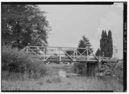 South Fork crossing SR 508
|
|
| Country | United States |
|---|---|
| State | Washington |
| County | Lewis |
| Source | Confluence of North and South Forks |
| - coordinates | 46°36′18″N 122°51′19″W / 46.60500°N 122.85528°W |
| Mouth | Chehalis River |
| - elevation | 161 ft (49 m) |
| - coordinates | 46°39′4″N 122°58′54″W / 46.65111°N 122.98167°WCoordinates: 46°39′4″N 122°58′54″W / 46.65111°N 122.98167°W |
| Length | 10.9 mi (17.5 km) |
| Basin | 173 sq mi (448 km2) |
| Discharge | for river mile 4.1 near Chehalis, WA |
| - average | 500 cu ft/s (14.2 m3/s) |
| - max | 10,200 cu ft/s (288.8 m3/s) |
| - min | 14 cu ft/s (0.4 m3/s) |
 Location of the mouth of the Newaukum River in Washington
|
|
The Newaukum River is a tributary of the Chehalis River in the U.S. state of Washington. It has three main branches, the North Fork, South Fork, and Middle Fork Newaukum Rivers. The length of the three forks and the mainstem river is 56.7 miles (91.2 km).
The river's name comes from the Upper Chehalis word náwaqwəm, meaning "big prairie".
Formed by the confluence of the North and South Forks in Newaukum Prairie, the mainstem Newaukum River flows generally west and north. After 10.9 miles (17.5 km), near the city of Chehalis, the Newaukum River empties into the Chehalis River, at Chehalis river mile 75.2.
The South Fork Newaukum River originates at Newaukum Lake in the Cascade Range, at 46°39′59″N 122°28′33″W / 46.666494°N 122.475947°W. It flows generally west. It exits the mountains and enters broad valleys and prairie lands, flowing by the community of Onalaska. The river turns north in Newaukum Prairie and joins the North Fork to form the mainstem Newaukum River.
The North Fork Newaukum River originates in the Cascade Range at 46°42′26″N 122°35′15″W / 46.707326°N 122.587617°W. It flows generally west for approximately 19 miles (31 km), entering a broad valley near its confluence with Mitchell Creek, after which it flows south and southwest. In Newaukum Prairie it is joined by the Middle Fork Newaukum River. Shortly below the Middle Fork confluence the North Fork joins the South Fork to form the mainstem Newaukum River.
...
Wikipedia