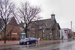
Westboro, Ottawa
| Westboro | |
|---|---|
| Neighbourhood | |

Former Westboro Town Hall
|
|
| Location in Ottawa | |
| Coordinates: 45°23′50″N 75°44′36″W / 45.39722°N 75.74333°W | |
| Country | Canada |
| Province | Ontario |
| City | Ottawa |
| Established | 19th Century |
| Incorporated | 1905 (Police Village of Westboro) |
| Annexation | 1949 (City of Ottawa) |
| Government | |
| • Mayor | Jim Watson |
| • MPs | Catherine McKenna, Anita Vandenbeld |
| • MPPs | Yasir Naqvi, Bob Chiarelli |
| • Councillors | Jeff Leiper, Mark Taylor |
| Elevation | 70 m (230 ft) |
| Population (2011) | |
| • Total | 22,000 |
| Canada 2011 Census | |
| Time zone | Eastern (EST) (UTC−5) |
| • Summer (DST) | EDT (UTC−4) |
Westboro (often referred to as Westboro Village) is an area in the west end of Ottawa, Canada. Located along the Ottawa River, the neighbourhood is bordered on the east by Island Park Drive. Westboro's northern border is defined by the Ottawa River. Under this definition, the population of the area is 21,280 (2011 Census).
Its community association boundaries are the Transitway to the north, Tweedsmuir Avenue to the east, Carling Avenue to the south and Denbury Avenue to the west. This area excludes the neighbourhood of Westboro Beach, whose community association borders include the area immediately north of Westboro, west of Island Park Drive.
The neighbourhood got its start in the late nineteenth century, when flyers were published proclaiming 'Move to Westboro,' and offering prospective residents 'views of the Laurentian Mountains.' This slightly creative name for the distant geological formation along the Eardley escarpment is now better known as the Gatineau Hills. The Gatineau Hills can be seen across the Ottawa River.
Nineteenth-century descriptions of the neighbourhood refer to its location along the Macadam Road to Bells Corners. That road is now known as Richmond Road, and where it slices through Westboro it is the commercial heart of the Village-like neighbourhood, once the centre of the old Nepean Township. The old Town Hall on Richmond Road used to house the bell that later became the symbol of the former city of Nepean, now a part of the city of Ottawa. The Maplelawn Garden, boasting the second oldest building in Ottawa (built in 1831) and designated a National Historic Site, is located at the western edge of the village.
...
Wikipedia

