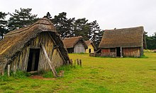
West Stow Anglo-Saxon village

West Stow Anglo-Saxon Village, summer 2012.
|
|
| Established | 1999 |
|---|---|
| Location | West Stow, Suffolk |
| Coordinates | 52°18′09″N 0°40′04″E / 52.3025°N 0.6679°E |
| Type | Archaeological open-air museum |
| Website | Stow Anglo-Saxon Village |
West Stow Anglo-Saxon Village is an archaeological site and an open-air museum located near to West Stow in Suffolk, eastern England. Evidence for intermittent human habitation at the site stretches from the Mesolithic through the Neolithic, Bronze Age, Iron Age and Romano-British period, but it is best known for the small village that existed on the site between the mid-5th century and the early 7th century CE, during the early Anglo-Saxon period. During this time, around 70 sunken-featured buildings were constructed on the site, along with 8 halls and a number of other features. Subsequently abandoned, the area became farmland in the Late Medieval period.
Antiquarian interest in the site began in 1849, when a nearby Anglo-Saxon cemetery was discovered. Subsequent excavations of Romano-British pottery kilns took place in the late 19th and mid-20th centuries, before the Anglo-Saxon settlement was revealed. The site was excavated between 1956 and 1972 by an archaeological team from the Ministry of Public Buildings and Works (MOPBW), led first by Vera Evison and then by Stanley West. Following the culmination of excavation, it was decided to reconstruct the village on the site, an experimental archaeological project which has been ongoing since 1974. In 1999, the site was opened to the public with a new visitor's centre, museum and cafe.
West Stow Anglo-Saxon Village is located on the north bank of the River Lark, adjacent to the village of West Stow in the western part of Suffolk. Situated on a small hill 15 feet (4.6 m) in height, it would have been noticeably prominent in the surrounding landscape; this hill formed a "core" for a sand dune that developed around it during the early 14th century and which sharply drops on the prevailing side while gradually sloping on the side which faces the prevailing winds. The steep southern slope is accentuated by a ditch at its base, which marks the edge of the river's flood plain.
...
Wikipedia

