West Islip, NY
| West Islip, New York | |
|---|---|
| Hamlet and census-designated place | |
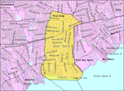
 U.S. Census map |
|
| Location within the state of New York | |
| Coordinates: 40°42′54″N 73°17′52″W / 40.71500°N 73.29778°WCoordinates: 40°42′54″N 73°17′52″W / 40.71500°N 73.29778°W | |
| Country | United States |
| State | New York |
| County | Suffolk |
| Area | |
| • Total | 6.8 sq mi (17.5 km2) |
| • Land | 6.3 sq mi (16.4 km2) |
| • Water | 0.4 sq mi (1.1 km2) |
| Elevation | 20 ft (6 m) |
| Population (2010) | |
| • Total | 28,335 |
| • Density | 4,200/sq mi (1,600/km2) |
| Time zone | Eastern (EST) (UTC-5) |
| • Summer (DST) | EDT (UTC-4) |
| ZIP code | 11795 |
| Area code(s) | 631, 516 |
| FIPS code | 36-80302 |
| GNIS feature ID | 0969276 |
West Islip is a hamlet and CDP located in the Town of Islip in Suffolk County, New York, United States. Situated on the South Shore of Long Island, the population of the CDP was 28,335 at the time of the 2010 census.
West Islip is located at 40°42′54″N 73°17′52″W / 40.71500°N 73.29778°W (40.715008, -73.297746).
According to the United States Census Bureau, the CDP has a total area of 6.8 square miles (17.5 km2), of which 6.3 square miles (16.4 km2) is land and 0.42 square miles (1.1 km2), or 6.46%, is water.
Great South Bay, Jones Beach Island and Fire Island lie to the south. Babylon and North Babylon form the western border. Bay Shore lies to the east, and in the north West Islip borders on Deer Park and Brentwood. West Islip is 45 miles (72 km) east of Manhattan and 45 miles (72 km) west of Southampton, New York. West Islip's western boundary is a natural one formed by Sampawams Creek, Hawley's Lake, Deer Lake and Swan Creek.
...
Wikipedia

