West Dundee, Illinois
| West Dundee | |
| Village | |
|
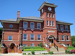
Village Hall
|
|
| Official name: Village of West Dundee | |
| Country | United States |
|---|---|
| State | Illinois |
| County | Kane |
| Township | Dundee |
| Coordinates | 42°5′43″N 88°17′9″W / 42.09528°N 88.28583°WCoordinates: 42°5′43″N 88°17′9″W / 42.09528°N 88.28583°W |
| Area | 3.82 sq mi (10 km2) |
| - land | 3.71 sq mi (10 km2) |
| - water | 0.10 sq mi (0 km2) |
| Population | 7,975 (2008) |
| Density | 2,998/sq mi (1,158/km2) |
| Government | The Village of West Dundee, Kane County, Illinois is a home rule municipality as provided under Article VII, Section 6 of the Constitution of the State of Illinois. |
| Village President | Christopher Nelson |
| Timezone | CST (UTC-6) |
| - summer (DST) | CDT (UTC-5) |
| Postal code | 60118 |
| Area code | 847 |
|
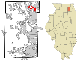
Location in Kane County and the state of Illinois.
|
|
West Dundee is a village in Kane County, Illinois, United States. The population was 7,331 as of the 2010 US Census. It is considered a far west Chicago suburb.
West Dundee lies across the Fox River from East Dundee and Carpentersville.
West Dundee is located at 42°5′43″N 88°17′9″W / 42.09528°N 88.28583°W (42.095327, -88.285809).
According to the 2010 census, West Dundee has a total area of 3.811 square miles (9.87 km2), of which 3.71 square miles (9.61 km2) (or 97.35%) is land and 0.101 square miles (0.26 km2) (or 2.65%) is water.
As of the census of 2000, there were 5,428 people, 2,059 households, and 1,453 families residing in the village. The population density was 2,040.5 people per square mile (787.9/km²). There were 2,103 housing units at an average density of 790.6 per square mile (305.3/km²). The racial makeup of the village was 93.92% White, 0.61% African American, 0.39% Native American, 2.21% Asian, 1.40% from other races, and 1.47% from two or more races. Hispanic or Latino of any race were 4.26% of the population.
...
Wikipedia


