West Coast District Municipality
|
West Coast Weskus |
||
|---|---|---|
| District municipality | ||
|
||
 Location in South Africa |
||
 Local municipalities within the West Coast |
||
| Coordinates: 32°30′S 18°45′E / 32.500°S 18.750°ECoordinates: 32°30′S 18°45′E / 32.500°S 18.750°E | ||
| Country | South Africa | |
| Province | Western Cape | |
| Seat | Moorreesburg | |
| Local municipalities | ||
| Government | ||
| • Type | Municipal council | |
| • Mayor | Herbrecht Kitshoff (DA) | |
| Area | ||
| • Total | 31,119 km2 (12,015 sq mi) | |
| Population (2011) | ||
| • Total | 391,766 | |
| • Density | 13/km2 (33/sq mi) | |
| Racial makeup (2011) | ||
| • Black African | 16.4% | |
| • Coloured | 66.6% | |
| • Indian/Asian | 0.6% | |
| • White | 15.7% | |
| First languages (2011) | ||
| • Afrikaans | 83.7% | |
| • Xhosa | 8.6% | |
| • English | 4.0% | |
| • Sotho | 1.3% | |
| • Other | 2.4% | |
| Time zone | SAST (UTC+2) | |
| Municipal code | DC1 | |
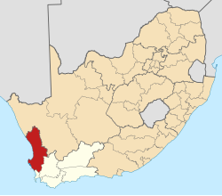
The West Coast District Municipality is a district municipality located in the Western Cape province of South Africa. Its municipality code is DC1. Moorreesburg is the seat of the district. As of 2011 it had a total population of 391,766.
The municipality, which covers an area of 31,119 square kilometres (12,015 sq mi), lies along the Atlantic coast of the Western Cape, extending approximately 350 kilometres (220 mi) from north to south. It includes the coastal plain and is generally bounded on the east by the mountains of the escarpment, though in the case of the Cederberg mountains the border passes further to the east, along the Doring River, so that the mountains are included in the municipal area. The principal rivers in the area are the Berg River, which drains the southern part of the municipality, and the Olifants River, which drains the Cederberg and the northern part of the municipality.
The southernmost part of the district, adjacent to Cape Town, is known as the Swartland and is primarily a grain-farming area. The Berg River flows across the Swartland from its sources in the Boland mountains. On the coast west of the Swartland is the Cape Columbine peninsula, with a number of coastal holiday resorts as well as the ore-export harbour at Saldanha Bay. On the north the Swartland is bounded by mountains which separate it from the Olifants River Valley.
The upper valley of the Olifants is predominantly a citrus-farming region. The Cederberg mountains, much of which are a protected wilderness area, rise from the eastern bank of the river, while along the coast to the west are fishing and holiday villages. The Olifants river continues northwards until, on the edge of the Knersvlakte, it turns west towards the Atlantic. In the lower valley there is a narrow strip of lush agricultural land irrigated by the river's water. The Knersvlakte, which is part of the arid Namaqualand region, forms the northernmost part of the district.
...
Wikipedia

