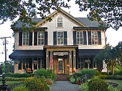
West Cape May, New Jersey
| West Cape May, New Jersey | |
|---|---|
| Borough | |
| Borough of West Cape May | |

|
|
 West Cape May Borough highlighted in Cape May County. Inset map: Cape May County highlighted in the State of New Jersey. |
|
 Census Bureau map of West Cape May, New Jersey |
|
| Coordinates: 38°56′32″N 74°56′21″W / 38.942226°N 74.939033°WCoordinates: 38°56′32″N 74°56′21″W / 38.942226°N 74.939033°W | |
| Country | |
| State |
|
| County | Cape May |
| Incorporated | April 17, 1884 |
| Named for | Cape May / Cornelius Jacobsen May |
| Government | |
| • Type | Walsh Act |
| • Body | Board of Commissioners |
| • Mayor | Pamela Kaithern (term ends December 31, 2017) |
| • Clerk | Elaine Wallace |
| Area | |
| • Total | 1.175 sq mi (3.044 km2) |
| • Land | 1.165 sq mi (3.018 km2) |
| • Water | 0.010 sq mi (0.026 km2) 0.86% |
| Area rank | 487th of 566 in state 14th of 16 in county |
| Elevation | 10 ft (3 m) |
| Population (2010 Census) | |
| • Total | 1,024 |
| • Estimate (2015) | 1,016 |
| • Rank | 533rd of 566 in state 13th of 16 in county |
| • Density | 878.8/sq mi (339.3/km2) |
| • Density rank | 399th of 566 in state 9th of 16 in county |
| Time zone | Eastern (EST) (UTC-5) |
| • Summer (DST) | Eastern (EDT) (UTC-4) |
| ZIP code | 08204 |
| Area code(s) | 609 |
| FIPS code | 3400978530 |
| GNIS feature ID | 0885435 |
| Website | www |
West Cape May is a Walsh Act borough in Cape May County, New Jersey, United States. It is part of the Ocean City Metropolitan Statistical Area. As of the 2010 United States Census, the borough's population was 1,024, reflecting a decline of 71 (-6.5%) from the 1,095 counted in the 2000 Census, which had in turn increased by 69 (+6.7%) from the 1,026 counted in the 1990 Census.
West Cape May was incorporated as a borough by an act of the New Jersey Legislature on April 17, 1884, from portions of Lower Township, based on the results of a referendum held two days earlier. The borough was reincorporated on April 11, 1890, and again on May 4, 1897. The borough's name derives from Cape May, which was named for 1620 Dutch captain named Cornelius Jacobsen May who explored and charted the area between 1611–1614, and established a claim for the province of New Netherland.
During Hurricane Sandy in October 2012, West Cape May was hit by 9.53 inches (242 mm) of rain, the most of any place in the state.
It is a no longer a dry town, after the Board of Commissioners approved the sale of a liquor license for more than $600,000 to a store that opened in May 2012. In 2008, voters approved a referendum that allowed the issuance of a single license for retail liquor sales and another for sale of alcoholic beverages at a restaurant. The borough had been dry for 128 years, where alcohol cannot be sold, affirmed by the results of a referendum held in 1940, joining Cape May Point, Ocean City and Wildwood Crest among municipalities in Cape May restricting the sale of alcohol.
...
Wikipedia
