West Canada Creek
| West Canada Creek | |
| River | |
|
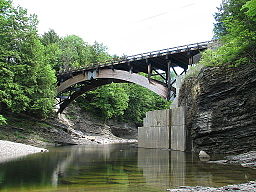
View of West Canada Creek in Prospect Gorge
|
|
| Country | United States |
|---|---|
| State | New York |
| Counties | Hamilton, Oneida, Herkimer |
| Tributaries | |
| - left | South Branch West Canada Creek |
| - right | Honnedaga Brook, Cincinnati Creek |
| Source | West Canada Lakes |
| - location | Town of Arietta, Hamilton County |
| - coordinates | 43°35′14″N 74°36′49″W / 43.58722°N 74.61361°W |
| Mouth | Mohawk River |
| - location | Village of Herkimer, Herkimer County |
| - coordinates | 43°01′16″N 74°57′46″W / 43.02111°N 74.96278°WCoordinates: 43°01′16″N 74°57′46″W / 43.02111°N 74.96278°W |
| Length | 76 mi (122 km) |
| Basin | 569 sq mi (1,474 km2) |
| Discharge | for Kast Bridge, 4 miles (6.4 km) upstream from mouth |
| - average | 1,356 cu ft/s (38 m3/s) |
| - max | 25,300 cu ft/s (716 m3/s) (June 28, 2013) |
| - min | 20 cu ft/s (1 m3/s) (September 3, 1929) |
The West Canada Creek is a 76-mile-long (122 km)river in upstate New York, United States. West Canada Creek is an important water way in Hamilton, Oneida, and Herkimer counties, draining the south part of the Adirondack Mountains before emptying into the Mohawk River near the Village of Herkimer. The name "Canada" is derived from a Native American word for "village" (Kanata).
A series of waterfalls in the Prospect Gorge, principally Trenton Falls, was a major tourist attraction in the past. Today, the West Canada is used by public utilities for power generation, and is used by the public for trout fishing, tubing, and other outdoor recreational pursuits. For fishing and fly fishing advocates, a trophy section exists from Trenton Falls to the Oneida/Herkimer county border, also known as Comstock Bridge. Efforts to balance the impacts of power generation and the habitat needs of wild trout in West Canada Creek have been undertaken by advocacy groups such as the Trout Power Initiative.
The timber, fish, and game of the area have been harvested for centuries. Today, all of the West Canada Creek is classified and protected under the New York State Wild, Scenic and Recreational Rivers System Act.
The West Canada Creek got its name from being the western boundary of Sir William Johnson's Royal Land Grant, and because the St. Lawrence Iroquoian word for village is Kanata or Canada. The name "Canada" may also refer to the creek's importance as a trail to Canada in colonial times. The creek was also known by Native Americans as Te-ugh-ta-ra-row , meaning "its waters are discolored"; the color of the creek that resulted from its sources in the forest also gave rise to another historical name, "Amber Creek".
...
Wikipedia


