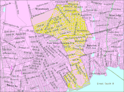
West Babylon, New York
| West Babylon, New York | |
|---|---|
| Census-designated place | |
 U.S. Census map |
|
| Location within the state of New York | |
| Coordinates: 40°42′48″N 73°21′26″W / 40.71333°N 73.35722°WCoordinates: 40°42′48″N 73°21′26″W / 40.71333°N 73.35722°W | |
| Country | United States |
| State | New York |
| County | Suffolk |
| Area | |
| • Total | 8.1 sq mi (20.9 km2) |
| • Land | 7.8 sq mi (20.1 km2) |
| • Water | 0.3 sq mi (0.8 km2) |
| Elevation | 39 ft (12 m) |
| Population (2010) | |
| • Total | 43,213 |
| • Density | 5,400/sq mi (2,100/km2) |
| Time zone | Eastern (EST) (UTC-5) |
| • Summer (DST) | EDT (UTC-4) |
| ZIP codes | 11704, 11707 |
| Area code(s) | 631 |
| FIPS code | 36-79246 |
| GNIS feature ID | 0969082 |
West Babylon is a census-designated place (CDP) in the Town of Babylon in Suffolk County, New York, United States. The population was 43,213 at the 2010 census.
West Babylon is located at 40°43′49″N 73°21′27″W / 40.73028°N 73.35750°W (40.713399, -73.357106).
West Babylon is bordered to the west by Lindenhurst and North Lindenhurst, to the northwest by East Farmingdale, to the north by Wyandanch, to the northeast by Deer Park, to the east by North Babylon and the Village of Babylon, and to the south by the Great South Bay.
According to the United States Census Bureau, the CDP has a total area of 8.0 square miles (21 km2), of which 7.7 square miles (20 km2) is land and 0.3 square miles (0.78 km2), or 3.87%, is water.
The peninsula in the southwest of the CDP is known as Venetian Shores. Served by the Lindenhurst Post Office and School District, this area is almost always considered a part of Lindenhurst.
...
Wikipedia

