Welshpool Road
|
Welshpool Road Welshpool Road East Western Australia |
|||||
|---|---|---|---|---|---|
 |
|||||
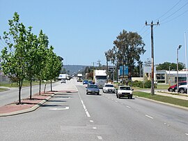
| View east along Welshpool Road in Welshpool | |||||
| Type | Road | ||||
| Length | 15 km (9.3 mi) | ||||
| Route number(s) |
|
||||
| Former route number |
|
||||
|
|||||
| West end |
|
||||
|
|||||
| East end | William Street, Welshpool | ||||
|
|||||
| West end |
|
||||
|
|||||
| East end |
|
||||
|
|
|||||
| Major suburbs | Queens Park, Wattle Grove, Lesmurdie | ||||
| Welshpool Road | |
|---|---|
| Welshpool Road East | |
|---|---|
Welshpool Road is a major arterial road running through the metropolitan area of Perth, Western Australia. Although the road is now split in two, having had its western and eastern sections disconnected due to the extension of Roe Highway, it remains Welshpool's second most important road (after Orrong Road), and the highest quality access road for the Darling Scarp.
Welshpool Road East is part of State Route 8, while the entire road was previously allocated State Route 35.
Welshpool Road west of Roe Highway is 5.5 km long, and unlike Welshpool Road East, did not have the West suffix added after the road's disconnection. The road is typical of those major in the Welshpool Area; although of a reasonable quality, being a 4 lane single or dual carriageway it contains only a handful of traffic lights, is choked by traffic in peak hour, has industrial business dotting the road, and has many minor roads which have no form of control, give way and stop signs excepted.
Welshpool Road begins as an extension of a west-east section of Albany Highway (Albany Highway continues to the south of the intersection). Continuing through Welshpool, it meets Leach Highway soon after. Leach Highway marks the most dangerous intersection for both Welshpool Road and Leach Highway; the intersection is also one of Perth's busiest. It then meets Kewdale Road, passing through outer Welshpool after this point. The final controlled intersection for the road is McDowell street. McDowell street extends north, meets Orrong Road, and then continues into neighbouring Kewdale. Although of importance for barely 300 metres, McDowell Street distributes traffic onto Orrong Road, allowing motorists to continue their journey along Welshpool Road East.
For those who continue along Welshpool Road, the road sharply turns south after 500 metres, and continues as William Street.
Welshpool Road East (9.5 km long) had an East suffix added after the road's disconnection. At a similar quality to Welshpool Road, its 4 lane section is an entire dual carriageway; it changes to a 2 to 3 lane single carriageway after climbing most of the Darling Scarp, however. With only 4 traffic lights in total (two of those at Roe Highway's diamond interchange), traffic problems are relatively minor, the only congestion being towards Roe Highway westbound.
...
Wikipedia
