Darling Scarp
| Darling Scarp | |
|---|---|
| Darling Range | |

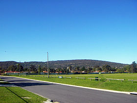
The Darling Scarp in the background, as viewed from the Swan Coastal Plain.
|
|
| Highest point | |
| Peak | Mount Cooke |
| Elevation | 582 m (1,909 ft) AHD |
| Geography | |
| Country | Australia |
| State | Western Australia |
| Geology | |
| Formed by | Darling Fault |
| Age of rock | Cenozoic |
The Darling Scarp, also referred to as the Darling Range or Darling Ranges, is a low escarpment running north-south to the east of the Swan Coastal Plain and Perth, Western Australia. The escarpment extends generally north of Bindoon, to the south of Pemberton. The adjacent Darling Plateau goes easterly to include Mount Bakewell near York and Mount Saddleback near Boddington. It was named after the Governor of New South Wales Lieutenant-General Ralph Darling.
The feature was first recorded as General Darling Range by Charles Fraser, Government Botanist with Captain James Stirling aboard HMS Success in March 1827.
Maps from the 1830s show the scarp labelled "General Darlings Range"; this later became Darling Range, a name by which the formation was still commonly known in the late 20th century, despite common understanding of it being an escarpment. There is also a tendency to identify the locations on or to the east of the scarp as being in the "Perth Hills" (or simply "The Hills").
The earliest traverses by British settlers in the Swan River Colony occurred in the 1830s. The best known of these is the expedition of Ensign Robert Dale, who appears to have gone from a point near Guildford, to the south side of Greenmount Hill and up through the Helena Valley.
...
Wikipedia
