Wells Township, Bradford County, Pennsylvania
| Wells Township, Bradford County, Pennsylvania |
|
|---|---|
| Township | |

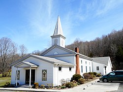
Mosherville Bible Church
|
|
 Map of Bradford County with Wells Township highlighted |
|
 Map of Bradford County, Pennsylvania |
|
| Country | United States |
| State | Pennsylvania |
| County | Bradford |
| Settled | 1792 |
| Incorporated | 1813 |
| Area | |
| • Total | 33.9 sq mi (87.7 km2) |
| • Land | 33.7 sq mi (87.4 km2) |
| • Water | 0.1 sq mi (0.3 km2) |
| Population (2010) | |
| • Total | 2,279 |
| • Estimate (2016) | 806 |
| • Density | 24/sq mi (9.3/km2) |
| Area code(s) | 570 |
| FIPS code | 42-015-82144 |
Wells Township is a township in Bradford County, Pennsylvania, United States. The population was 814 at the 2010 census.
Wells Township is located in the northwest corner of Bradford County, along the New York state line. It is bordered by South Creek Township to the east, Columbia Township to the south and Rutland and Jackson townships in Tioga County to the west. To the north, in Chemung County, New York, is the town of Southport. The primary settlement in the township is the unincorporated community of Mosherville, in the valley of Seeley Creek in the northwest. Children residing in the township are assigned to attend the Troy Area School District.
According to the United States Census Bureau, the township has a total area of 33.9 square miles (87.7 km2), of which 33.7 square miles (87.4 km2) is land and 0.12 square miles (0.3 km2), or 0.30%, is water.
As of the census of 2000, there were 1,278 people, 462 households, and 353 families residing in the township. The population density was 37.7 people per square mile (14.5/km²). There were 538 housing units at an average density of 15.9/sq mi (6.1/km²). The racial makeup of the township was 99.45% White, 0.16% Native American, and 0.39% from two or more races. Hispanic or Latino of any race were 0.23% of the population.
...
Wikipedia
