Wayne Township, Clinton County, Pennsylvania
| Wayne Township, Clinton County, Pennsylvania |
|
|---|---|
| Township | |

Small dam on McElhattan Creek, Wayne Township, Clinton County, within Zindel Park
|
|
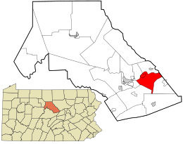
 Location in Clinton County and the state of Pennsylvania. |
|
| Country | United States |
| State | Pennsylvania |
| County | Clinton |
| Settled | 1768 |
| Incorporated | Before 1839 |
| Area | |
| • Total | 22.9 sq mi (59.2 km2) |
| • Land | 22.3 sq mi (57.8 km2) |
| • Water | 0.5 sq mi (1.4 km2) |
| Population (2010) | |
| • Total | 1,666 |
| • Estimate (2016) | 1,693 |
| • Density | 75/sq mi (28.8/km2) |
| FIPS code | 42-035-81728 |
| Website | wayne-township |
Wayne Township is a township in Clinton County, Pennsylvania, United States. As of the 2010 census, the township had a population of 1,666, up from 1,363 at the 2000 census.
Wayne Township is in southeastern Clinton County and is bordered on the east by Lycoming County. The West Branch Susquehanna River forms the winding northern border of the township. The unincorporated community of McElhattan is in the north, along the West Branch. U.S. Route 220, a four-lane freeway, passes through the township, with access from one exit. US 220 leads west 6 miles (10 km) to Lock Haven, the county seat, and east 7 miles (11 km) to Jersey Shore.
According to the United States Census Bureau, the township has a total area of 22.9 square miles (59.2 km2). 22.3 square miles (57.8 km2) of it is land and 0.54 square miles (1.4 km2), or 2.40%, is water.
As of the census of 2000, there are 1,363 people, 477 households, and 353 families residing in the township. The population density is 23.6/km² (61.1/sq mi). There are 496 housing units at an average density of 8.6/km² (22.2/sq mi). The racial makeup of the township is 98.17% White, 1.32% African American, 0.15% Asian, 0.07% from other races, and 0.29% from two or more races. 0.51% of the population are Hispanic or Latino of any race.
...
Wikipedia
