Clinton County, Pennsylvania
| Clinton County, Pennsylvania | |
|---|---|

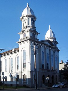
Clinton County Courthouse
|
|
 Location in the U.S. state of Pennsylvania |
|
 Pennsylvania's location in the U.S. |
|
| Founded | June 21, 1839 |
| Named for | DeWitt Clinton |
| Seat | Lock Haven |
| Largest city | Lock Haven |
| Area | |
| • Total | 897 sq mi (2,323 km2) |
| • Land | 888 sq mi (2,300 km2) |
| • Water | 8.9 sq mi (23 km2), 1.0% |
| Population (est.) | |
| • (2015) | 39,441 |
| • Density | 44/sq mi (17/km²) |
| Congressional district | 5th |
| Time zone | Eastern: UTC-5/-4 |
| Website | www |
| Footnotes: | |
| Designated | June 12, 1982 |
Coordinates: 41°14′N 77°38′W / 41.24°N 77.64°W
Clinton County is a county located in the U.S. state of Pennsylvania. As of the 2010 census, the population was 39,238. Its county seat is Lock Haven. The county was created on June 21, 1839, from parts of Centre and Lycoming Counties. Its name is in honor of the seventh Governor of New York State, DeWitt Clinton, however some sources suggest the namesake is Henry Clinton.
Clinton County comprises the Lock Haven, PA Micropolitan Statistical Area, which is also included in the Williamsport-Lock Haven, PA Combined Statistical Area.
According to the U.S. Census Bureau, the county has a total area of 897 square miles (2,320 km2), of which 888 square miles (2,300 km2) is land and 8.9 square miles (23 km2) (1.0%) is water.
...
Wikipedia
