Wayne Township, Allen County, Indiana
| Wayne Township | |
|---|---|
| Township | |

Horney Robinson House, a historic site in the township
|
|
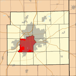
 Location of Wayne Township in Allen County, Indiana |
|
| Coordinates: 41°02′58″N 85°09′53″W / 41.04944°N 85.16472°WCoordinates: 41°02′58″N 85°09′53″W / 41.04944°N 85.16472°W | |
| Country | United States |
| State | Indiana |
| County | Allen |
| Government | |
| • Type | Indiana township |
| Area | |
| • Total | 42.25 sq mi (109.43 km2) |
| • Land | 42.13 sq mi (109.11 km2) |
| • Water | 0.12 sq mi (0.32 km2) |
| Elevation | 774 ft (236 m) |
| Population (2010) | |
| • Total | 103,803 |
| • Density | 2,464/sq mi (951.3/km2) |
| FIPS code | 18-81620 |
| GNIS feature ID | 454027 |
| Website | www |
Wayne Township is one of twenty townships in Allen County, Indiana, United States. As of the 2010 census, its population was 103,803.
The Horney Robinson House was listed on the National Register of Historic Places in 1985.
Wayne Township covers an area of 42.25 square miles (109.43 km2), of which 42.13 square miles (109.11 km2) is land and 0.12 square miles (0.32 km2), or 0.29%, is water.
The township is adjacent to these Indiana townships:
The township contains three cemeteries: Lindenwood, Prairie Grove, and Saint Johns.
...
Wikipedia
