Wassenaar
| Wassenaar | |||
|---|---|---|---|
| Municipality | |||

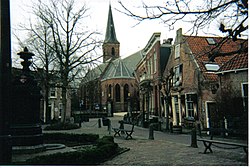
Historical town square in Wassenaar
|
|||
|
|||
 Location in South Holland |
|||
| Coordinates: 52°9′N 4°24′E / 52.150°N 4.400°ECoordinates: 52°9′N 4°24′E / 52.150°N 4.400°E | |||
| Country | Netherlands | ||
| Province | South Holland | ||
| Government | |||
| • Body | Municipal council | ||
| • Mayor | Jan Hoekema (D66) | ||
| Area | |||
| • Total | 62.37 km2 (24.08 sq mi) | ||
| • Land | 50.92 km2 (19.66 sq mi) | ||
| • Water | 11.45 km2 (4.42 sq mi) | ||
| Elevation | 1 m (3 ft) | ||
| Population (May 2014) | |||
| • Total | 25,768 | ||
| • Density | 506/km2 (1,310/sq mi) | ||
| Demonym(s) | Wassenaarder | ||
| Time zone | CET (UTC+1) | ||
| • Summer (DST) | CEST (UTC+2) | ||
| Postcode | 2240–2245 | ||
| Area code | 070 | ||
| Website | www |
||
Wassenaar (Dutch pronunciation: [ˈʋɑsənaːr]; population: 25,768 in 2014) is a town in the western Netherlands, in the province of South Holland.
An exceedingly affluent suburb of The Hague, in fact the second most prosperous municipality in the Netherlands after Bloemendaal, Wassenaar lies 10 km (6.2 mi) north of that city on the N44/A44 highway near the North Sea coast. It is part of the Haaglanden region. The municipality covers an area of 62.37 km2 (24.08 sq mi), of which 11.45 km2 (4.42 sq mi) is covered by water.
There are rumours that the 12th-century Romanesque church in Wassenaar lies on the spot where the Northumbrian missionary Willibrord once landed in the Netherlands; the high dunes to the west were not formed until later.
Wassenaar long remained an unremarkable little town, known only as the home of the House of Wassenaer. It only began to gain notoriety in the 19th century when Louis Bonaparte ordered the construction of the Heerweg ("Army Road") between The Hague and Leiden, which forms the current Rijksstraatweg. In approximately 1840, Prince Frederik had the De Paauw (Peacock) palace built, where he lived for many years; it now serves as the city hall of Wassenaar.
With the construction of the railway between Rotterdam, The Hague though Wassenaar towards its final destination the coastal area of Scheveningen in 1907, the course of which now forms the Landscheidingsweg. Wassenaar became attractive as a residence for wealthy people from Rotterdam.
...
Wikipedia


