Washington State Route 21
| State Route 21 | ||||
|---|---|---|---|---|

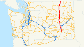
SR 21 is highlighted in red.
|
||||
| Route information | ||||
| Defined by RCW 47.17.085 | ||||
| Maintained by WSDOT | ||||
| Length: | 191.34 mi (307.93 km) | |||
| Existed: | 1964 – present | |||
| Major junctions | ||||
| South end: |
|
|||
|
|
||||
| North end: |
|
|||
| Location | ||||
| Counties: | Franklin, Adams, Lincoln, Ferry | |||
| Highway system | ||||
|
||||
State Route 21 (SR 21) is a 191.34-mile (307.93 km) long state highway in the U.S. state of Washington that traverses four counties: Franklin, Adams, Lincoln and Ferry. The highway extends from an intersection with SR 260 in Kahlotus north through Lind, Odessa, Clark, Keller, Republic and Curlew before becoming Highway 41 (BC 41) at the Canada–US border in Danville. SR 21 is concurrent with U.S. Route 2 (US 2) in Wilbur and SR 20 in Republic and has two diamond interchanges: at US 395 in Lind and Interstate 90 (I-90) south of Odessa. Between Lincoln and Ferry counties, the roadway crosses Franklin D. Roosevelt Lake on the Keller Ferry, operated fare free by the Washington State Department of Transportation (WSDOT) and the Department of Highways (DoH) since 1930.
...
Wikipedia

