Washington State Route 20
| State Route 20 | ||||
|---|---|---|---|---|
 |
||||
| Route information | ||||
| Defined by RCW 47.17.080 | ||||
| Maintained by WSDOT | ||||
| Length: | 436.13 mi (701.88 km) Mileage does not include ferry route |
|||
| Existed: | 1964 – present | |||
| Tourist routes: |
International Selkirk Loop | |||
| Major junctions | ||||
| West end: |
|
|||
| East end: |
|
|||
| Location | ||||
| Counties: | Jefferson, Island, Skagit, Okanogan, Ferry, Stevens, Pend Oreille | |||
| Highway system | ||||
|
||||
|
State Route 20 Spur |
|
|---|---|
| Location: | Anacortes, Washington |
| Existed: | 1964–present |
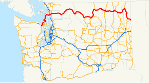
State Route 20 (SR 20), also known alternately as the North-Cross Highway or the North Cascades Highway, is a state route in the state of Washington. It travels from an intersection with U.S. Route 101 (US 101) at Discovery Bay near Port Townsend to Newport at a junction with US 2 about 400 feet (120 m) from the Idaho state line. It includes the Port Townsend–Keystone Ferry between the Olympic Peninsula and Whidbey Island. Although US 12 has a larger east–west extent, SR 20 is the longest highway in Washington at 436.13 miles (701.88 km), only 5.3 miles (8.5 km) longer than US 12. The highway has been called "The Most Beautiful Mountain Highway in the State of Washington."
What is known today as the North Cascades Highway was originally the corridor used by local Native American tribes as a trading route from Washington's Eastern Plateau country to the Pacific Coast for more than 8,000 years. After the California Gold Rush of 1849, white settlers started to arrive in the North Cascades looking for gold as well as fur-bearing animals. This far north, the settlers needed a clear route through some of the most rugged terrain in Washington Territory.
It wasn't until 1895, however, that funding to explore a possible route through the Cascade Range was appropriated.
...
Wikipedia

