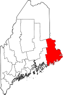
Washington County, ME
| Washington County, Maine | |
|---|---|

Washington County Courthouse
|
|
 Location in the U.S. state of Maine |
|
 Maine's location in the U.S. |
|
| Founded | June 25, 1789 |
| Named for | George Washington |
| Seat | Machias |
| Largest city | Calais |
| Area | |
| • Total | 3,258 sq mi (8,438 km2) |
| • Land | 2,563 sq mi (6,638 km2) |
| • Water | 695 sq mi (1,800 km2), 21% |
| Population (est.) | |
| • (2016) | 31,450 |
| • Density | 13/sq mi (5/km²) |
| Congressional district | 2nd |
| Time zone | Eastern: UTC-5/-4 |
| Website | washingtoncountymaine |
Washington County is a county located in the U.S. state of Maine. As of the 2010 census, its population was 32,856, making it the third-least populous county in Maine. Its county seat is Machias. The county was established on June 25, 1789. It borders the Canadian province of New Brunswick.
It is sometimes referred to as "Sunrise County" because it includes the easternmost point in the United States, and claims have been made that Washington County is where the sun first rises on the 48 contiguous states. Many small seaside communities have small-scale fishing-based economies. Tourism is also important along the county's shoreline, but it is not as important as elsewhere in the state. The blueberry crop plays a major role in the county's economy.
According to the U.S. Census Bureau, the county has a total area of 3,258 square miles (8,440 km2), of which 2,563 square miles (6,640 km2) is land and 695 square miles (1,800 km2) (21%) is water.
As of the census of 2000, there were 33,941 people, 14,118 households, and 9,303 families residing in the county. The population density was 13 people per square mile (5/km²). There were 21,919 housing units at an average density of 8 per square mile (3/km²). The racial makeup of the county was 93.48% White, 0.26% Black or African American, 4.43% Native American, 0.30% Asian, 0.01% Pacific Islander, 0.44% from other races, and 1.07% from two or more races. 0.81% of the population were Hispanic or Latino of any race.
...
Wikipedia
