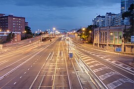
Warringah Freeway
|
Warringah Freeway New South Wales |
|
|---|---|
 |
|
| Southern terminus of the Warringah Freeway at its junction with the Sydney Harbour Bridge. | |
| Type | Freeway |
| Length | 3 km (1.9 mi) |
| Opened | 1968 - 1978 |
| Route number(s) |
|
| Former route number |
|
| NW end | |
Falcon St (A8)
|
|
| South end | |
| Major suburbs / towns | Crows Nest |
|
Highways in Australia National Highway • Freeways in Australia Highways in New South Wales |
|
Falcon St (A8)
The Warringah Freeway (also known as the Warringah Expressway) is a 3-kilometre (1.9 mi) divided freeway located in Sydney, New South Wales, Australia. The freeway forms part of the M1, the Sydney Orbital Network, and the Highway 1 network. The primary function of the freeway is to provide an alternative high-grade route from the Sydney Harbour Tunnel and the Bradfield Highway at Milsons Point to the A8 and the Gore Hill Freeway. The freeway reduces traffic demands on the Pacific Highway throughout Sydney's lower north shore, bypassing North Sydney and Crows Nest. Completed in a series of stages between June 1968 and August 1992, the Warringah Freeway provides a vital link to access most of the suburbs in Sydney and is also a major route to the north, south, east and west of the central business district.
Planning began in 1951. The first stage of the road opened on 18 June 1968. As its name suggests, the road was envisioned as the first stage of a freeway system for Sydney's Manly/Warringah area. An early alignment had the freeway crossing into the Manly Warringah area via Castlecrag, then later via Castle Cove. The freeway was never extended in this direction due to opposition by the residents of Castlecrag.
...
Wikipedia
