Warlaing
| Warlaing | ||
|---|---|---|
| Commune | ||

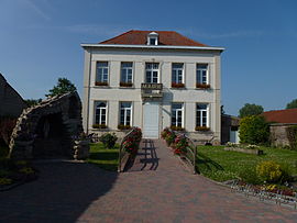
The town hall
|
||
|
||
| Coordinates: 50°24′40″N 3°19′34″E / 50.4111°N 3.3261°ECoordinates: 50°24′40″N 3°19′34″E / 50.4111°N 3.3261°E | ||
| Country | France | |
| Region | Hauts-de-France | |
| Department | Nord | |
| Arrondissement | Douai | |
| Canton | Sin-le-Noble | |
| Intercommunality | Cœur d'Ostrevent | |
| Government | ||
| • Mayor (2008–2014) | Patrice Bricout | |
| Area1 | 3.89 km2 (1.50 sq mi) | |
| Population (1999)2 | 461 | |
| • Density | 120/km2 (310/sq mi) | |
| Time zone | CET (UTC+1) | |
| • Summer (DST) | CEST (UTC+2) | |
| INSEE/Postal code | 59642 /59870 | |
| Elevation | 16–19 m (52–62 ft) (avg. 17 m or 56 ft) |
|
|
1 French Land Register data, which excludes lakes, ponds, glaciers > 1 km² (0.386 sq mi or 247 acres) and river estuaries. 2Population without double counting: residents of multiple communes (e.g., students and military personnel) only counted once. |
||
1 French Land Register data, which excludes lakes, ponds, glaciers > 1 km² (0.386 sq mi or 247 acres) and river estuaries.
Warlaing is a commune in the Nord department in northern France.
Or, a cross engrailed gules. (Artres, Bettrechies, Cerfontaine, Denain, Eth, Lesquin, Obies, Quérénaing, Semousies, Wambrechies and Warlaing use the same arms.)
The road into Warlaing
The Church of Our Lady of the Assumption
The grotto of Lourdes
The lock of the Scarpe
The bascule bridge on the Scarpe
...
Wikipedia


