Walterboro
| Walterboro, South Carolina | |
|---|---|
| City | |

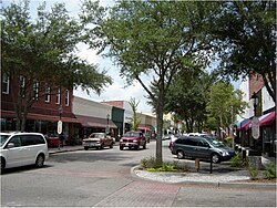
E. Washington Street in downtown Walterboro
|
|
| Motto: The Front Porch of the Lowcountry | |
 Location of Walterboro, South Carolina |
|
| Coordinates: 32°54′15″N 80°39′58″W / 32.90417°N 80.66611°WCoordinates: 32°54′15″N 80°39′58″W / 32.90417°N 80.66611°W | |
| Country | United States |
| State | South Carolina |
| County | Colleton |
| Area | |
| • Total | 6.5 sq mi (16.8 km2) |
| • Land | 6.5 sq mi (16.8 km2) |
| • Water | 0.0 sq mi (0.0 km2) |
| Elevation | 59 ft (18 m) |
| Population (2010) | |
| • Total | 5,398 |
| • Density | 832/sq mi (321.2/km2) |
| Time zone | Eastern (EST) (UTC-5) |
| • Summer (DST) | EDT (UTC-4) |
| ZIP code | 29488 |
| Area code(s) | 843 |
| FIPS code | 45-74275 |
| GNIS feature ID | 1251318 |
| Website | www |
Walterboro is a city in Colleton County, South Carolina, United States. The population was 5,398 at the 2010 census. It is the county seat of Colleton County. Walterboro is located 48 miles (77 km) west of Charleston and is located near the ACE Basin region in the South Carolina Lowcountry.
Walterboro (originally spelled "Walterborough") was founded in 1783 as a summer retreat for local planters looking to escape their malaria-ridden, Lowcountry plantations. The original settlement was located on a hilly area, covered with pine and hickory trees and named "Hickory Valley". Two of the earliest settlers were Paul and Jacob Walter. The two brothers owned plantations in nearby Jacksonboro. Paul's small daughter Mary was taken ill with malaria, a common disease amongst the families who built their plantations in the marshy areas of the Lowcountry, suitable to rice production. To save Mary's life the two brothers went looking for a more healthy location in which to live during the summer months and started the town that was later named for them. In 1817, Walterboro was named the third county seat of Colleton County, and has remained such until the present. This was followed by the construction of a county courthouse and jail in 1821, the courthouse being design by well-known architect Robert Mills. The town quickly spread out from the original Hickory Valley location, its population growth fueled successively by the town becoming the county seat in 1821, the establishment of a railroad line connecting the city with Columbia and Charleston in the 1880s, the establishment of an airfield in the 1930s and more recently the establishment of Interstate 95 in the 1960s, making the town a prime overnight stop on the road to Florida or New York.
...
Wikipedia
