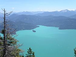
Walchensee
| Walchensee | |
|---|---|
 |
|
| Location | Kochel, Bavaria |
| Coordinates | 47°35′38″N 11°20′46″E / 47.59389°N 11.34611°ECoordinates: 47°35′38″N 11°20′46″E / 47.59389°N 11.34611°E |
| Primary inflows | Obernach |
| Primary outflows |
Jachen Lake Walchen Power Plant |
| Catchment area | 779.3 km2 (300.9 sq mi) |
| Basin countries | Germany |
| Max. length | 6.7 km (4.2 mi) |
| Max. width | 5 km (3.1 mi) |
| Surface area | 16.4 km2 (6.3 sq mi) |
| Average depth | 81.4 m (267 ft) |
| Max. depth | 192.3 m (631 ft) |
| Water volume | 1,324×106 m3 (46.8×10⁹ cu ft) |
| Surface elevation | 800.8 m (2,627 ft) |
| Islands | Sassau |
| Settlements | Kochel |
Walchensee or Lake Walchen is one of the deepest and largest alpine lakes in Germany, with a maximum depth of 192.3 metres (631 ft) and an area of 16.4 square kilometres (6.3 sq mi). The lake is 75 kilometres (47 mi) south of Munich in the middle of the Bavarian Alps. The entire lake, including the island of Sassau, is within the municipality of Kochel. To the east and the south, the lake borders the municipality of Jachenau.
The name Walchen comes from Middle High German and means "strangers". All Roman and romanized peoples of the Alps south of Bavaria were known to the locals as Welsche or even Walche. This is also true of the etymology of the Swiss Lake Walen and the Salzburg Wallersee.
Another possible interpretation is that it comes from the Latin Lacus vallensis, meaning "lake in a valley". On 16th-century maps, the lake is also labelled dicto Italico, meaning "leading to Italy", probably because the route through the Walchensee valley led through Mittenwald and Innsbruck to Italy.
Walchensee fills a tectonic valley, part of the Bayerisches Synklinorium (Bavarian Syncline) and from rocks of the triassic period (the main dolomite, Plattenkalke, and Kössener layers). The extreme depth of the lake, 192.3 metres (631 ft), is the result of this tectonic formation. The rock faces of the northwestern shore clearly show the steep arrangement of the rock layers. The creation of the lake from the forces of mountain building indicate that Walchensee could be one of the oldest lakes in Germany. During the ice age, the Isar–Loisach glacier repeatedly left its mark on the morphology of the area and thereby the Walchensee.
The mountain lake has a shoreline of approximately 27 kilometres (17 mi) and contains 1.3 cubic kilometres (0.31 cu mi) of water. The Jachen is the natural outflow of the lake, eastwards through the valley of Jachenau to the Isar. Obernach is the largest natural inflow to the lake, which flows in from the southwest. Together with the artificial inflow (see "Peculiarities"), the lake has a catchment basin of 780 square kilometres (300 sq mi).
...
Wikipedia
