Wakulla County, Florida
| Wakulla County, Florida | ||
|---|---|---|

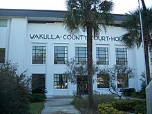
Wakulla County Courthouse
|
||
|
||
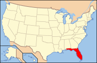
 Location in the U.S. state of Florida |
||
 Florida's location in the U.S. |
||
| Founded | March 11, 1843 | |
| Seat | Crawfordville | |
| Largest city | Sopchoppy | |
| Area | ||
| • Total | 736 sq mi (1,906 km2) | |
| • Land | 606 sq mi (1,570 km2) | |
| • Water | 129 sq mi (334 km2), 17.6% | |
| Population (est.) | ||
| • (2015) | 31,535 | |
| • Density | 51/sq mi (20/km²) | |
| Congressional district | 2nd | |
| Time zone | Eastern: UTC-5/-4 | |
| Website | www |
|
Wakulla County is a county located in the U.S. state of Florida. As of the 2010 census, the population was 30,776. Its county seat is Crawfordville.
Wakulla County is part of the Tallahassee, FL Metropolitan Statistical Area.
Wakulla County has a near-absence of any municipal population, with two small municipalities holding about 3% of the population. The county seat, Crawfordville, is one of only two unincorporated county seats among Florida's 67 counties.
In 1528, Panfilo de Narvaez found his way to what would be Wakulla County from the future Pinellas County, Florida, camping at the confluence of the Wakulla and St. Marks rivers. Narvaez determined this was a very suitable spot for a fort. In 1539, Hernando de Soto's expedition passed through La Florida with a similar route.
The Fort San Marcos de Apalache began with a wooden fort in the late 1600s. The vicinity around the fort was not settled until 1733. Spanish colonial officials began constructing a stone fort, which was unfinished in the mid-1760s when Great Britain took over.
The British divided Florida into East Florida, which included present-day Wakulla County, and West Florida. The boundary was the Apalachicola River; at that time, West Florida extended all the way to the Mississippi River. Twenty years later when the Spanish returned, they kept the East and West divisions, with the administrative capitals remaining at St. Augustine and Pensacola, respectively.
...
Wikipedia

