Wakool, New South Wales
|
Wakool New South Wales |
|
|---|---|

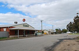
The main street of Wakool, looking south towards the general store. The Wakool Hotel is in the foreground.
|
|
| Coordinates | 35°28′0″S 144°23′0″E / 35.46667°S 144.38333°ECoordinates: 35°28′0″S 144°23′0″E / 35.46667°S 144.38333°E |
| Population | 213 (2006 census) |
| Postcode(s) | 2710 |
| Elevation | 80 m (262 ft) |
| Location |
|
| LGA(s) | Murray River Council |
| County | Wakool |
| State electorate(s) | Murray |
| Federal Division(s) | Farrer |
Wakool /wɔːˈkuːl/ is a town in the western Riverina region of New South Wales, Australia. Wakool is in the Murray River Council local government area, 791 kilometres (492 mi) south west of the state capital, Sydney and 336 kilometres (209 mi) north-west of Melbourne. At the 2006 census, Wakool had a population of 213.
Wakool Post Office opened on 1 January 1870 and closed in 1874. It reopened in 1926.
Closer settlement of the Wakool area commenced in the 1890s and the town grew around a railway station established on the line between Echuca and Balranald. In 1942, rice growing was established in the area. Other industries include wool and cattle.
The town includes a cafe/post office, hotel and services club. Education is available to primary level; High School students must travel to Barham or Deniliquin.
The town used to have an Australian rules football club in the Golden Rivers Football League until folding in 2015 due lack of players. The football club has rejoined the league and will compete in the 2017 season.
Wakool Main Street.
Wakool War Memorial.
Wakool Anglican Church.
Wakool Roman Catholic Church building.
...
Wikipedia

