Wake Village, Texas
| Wake Village, Texas | |
|---|---|
| City | |
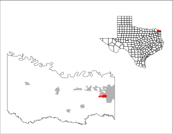
 Location of Wake Village, Texas |
|
 |
|
| Coordinates: 33°25′33″N 94°6′42″W / 33.42583°N 94.11167°WCoordinates: 33°25′33″N 94°6′42″W / 33.42583°N 94.11167°W | |
| Country | United States |
| State | Texas |
| County | Bowie |
| Area | |
| • Total | 2.3 sq mi (6.0 km2) |
| • Land | 2.3 sq mi (6.0 km2) |
| • Water | 0.0 sq mi (0.0 km2) |
| Elevation | 341 ft (104 m) |
| Population (2010) | |
| • Total | 5,492 |
| • Density | 2,370/sq mi (915.2/km2) |
| Time zone | Central (CST) (UTC-6) |
| • Summer (DST) | CDT (UTC-5) |
| ZIP code | 75501 |
| Area code(s) | 903 |
| FIPS code | 48-76096 |
| GNIS feature ID | 1370739 |
| Website | wakevillagetx |
Wake Village is a city in Bowie County, Texas, United States, and a suburb of Texarkana, Texas. It is part of the Texarkana, Texas - Texarkana, Arkansas Metropolitan Statistical Area. The population was 5,492 at the 2010 census.
Wake Village is located in eastern Bowie County at 33°25′33″N 94°6′42″W / 33.42583°N 94.11167°W (33.425701, -94.111716), immediately west of Texarkana, at the intersection of Farm to Market Road 989 and Old Redwater Road, north of U.S. Route 67 and south of U.S. Route 82. The city of Nash is situated immediately to the north, also along FM 989.
According to the United States Census Bureau, the city has a total area of 2.3 square miles (6.0 km2), all of it land.
Wake Village was founded in 1944/45 for the war effort to provide housing for the plant workers at the Red River Army Depot and the Lone Star Army Ammunition Plant.
The name came from Wake Island in the Pacific theater of the war. The population was over 1,000 in the early 1950s; in the early 1990s it had reached 4,400, and the 2000 census reported 5,129.
...
Wikipedia
