Wahpeton, North Dakota
| Wahpeton, North Dakota | |
|---|---|
| City | |

Dakota Avenue in downtown Wahpeton, 2007
|
|
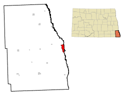
 Location of Wahpeton, North Dakota |
|
| Coordinates: 46°16′12″N 96°36′38″W / 46.27000°N 96.61056°WCoordinates: 46°16′12″N 96°36′38″W / 46.27000°N 96.61056°W | |
| Country | United States |
| State | North Dakota |
| County | Richland |
| Government | |
| • Mayor | Meryl Hansey |
| • Finance Director | Darcie Huwe |
| Area | |
| • Total | 5.29 sq mi (13.70 km2) |
| • Land | 5.29 sq mi (13.70 km2) |
| • Water | 0 sq mi (0 km2) |
| Elevation | 965 ft (294 m) |
| Population (2010) | |
| • Total | 7,766 |
| • Estimate (2015) | 7,899 |
| • Density | 1,468.1/sq mi (566.8/km2) |
| Time zone | Central (CST) (UTC-6) |
| • Summer (DST) | CDT (UTC-5) |
| ZIP codes | 58074-58076 |
| Area code(s) | 701 |
| FIPS code | 38-82660 |
| GNIS feature ID | 1033621 |
| Highways | ND 13, ND 210 |
| Website | wahpeton.com |
Wahpeton (/ˈwɑːpᵻtən/ WAH-pə-tən) is a city in Richland County, in southeastern North Dakota, United States. It is located along the Bois de Sioux River at its confluence with the Otter Tail River, forming the Red River of the North. Wahpeton is the county seat of Richland County. The U.S. Census Bureau estimated the city's 2015 population was 7,899.
Wahpeton was founded in 1869 and is the principal city of the Wahpeton Micropolitan Statistical Area, which includes all of Richland County, North Dakota and Wilkin County, Minnesota. Wahpeton's twin city is Breckenridge, Minnesota, located to the east on the other side of the river. The Bois de Sioux River and the Otter Tail River join at Wahpeton and Breckenridge to form the Red River of the North.
The North Dakota State College of Science is located in Wahpeton. The local newspaper is the Wahpeton Daily News.
...
Wikipedia
