W National Park
| W Transborder Park | |
|---|---|
|
IUCN category II (national park)
|
|

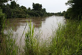
Mekrou River in the W-National Park
|
|
| IUCN Protected Areas of the WAP complex | |
| Location | Niger-Burkina Faso-Benin |
| Nearest city | Kandi (Benin), Diapaga (Burkina), Tapoa (Niger) |
| Coordinates | 12°31′31″N 2°39′48″E / 12.52528°N 2.66333°ECoordinates: 12°31′31″N 2°39′48″E / 12.52528°N 2.66333°E |
| Area | 10,000 km2 (3,900 sq mi) |
| Established | August 4, 1954 |
| Governing body | ECOPAS, Governments of Niger, Burkina Faso, and Benin |
| Official name | W National Park of Niger |
| Type | Natural |
| Criteria | vii, ix, x |
| Designated | 1996 (20th session) |
| Reference no. | 749 |
| State Party | Niger |
| Region | Africa |
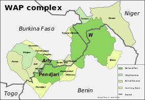
The W National Park or W Regional Park (French: "W" du Niger) is a major national park in West Africa around a meander in the River Niger shaped like a "W". The park includes areas of the three countries Niger, Benin and Burkina Faso, and is governed by the three governments. Until 2008, the implementation of a regional management was supported by the EU-funded Project ECOPAS (French: Ecosystèmes Protégés en Afrique Soudano-Sahélienne). The three national parks operate under the name W Transborder Park (French: Parc Regional W).
The W National Park of Niger was created by decree on 4 August 1954, and since 1996 has been listed as a UNESCO World Heritage Site. Within Niger, the Park is listed as a National Park, IUCN Type II, and is part of a larger complex of Reserves and protected areas. These include the adjacent Dallol Bosso (Wetlands of International Importance (Ramsar) on the eastern bank of the Niger River and the partial overlap of the smaller "Parc national du W" (Wetlands of International Importance (Ramsar). The three parks are BirdLife International Important Bird Areas (IBAs)of types A1 and A3 (IBA codes IBA NE001, IBA BF008, and IBA BJ001).
In the three nations, the Regional park covers some 10,000 km² largely uninhabited by humans, having been until the 1970s a Malarial zone of wetlands formed by the delta of the Mekrou River with the Niger, broken by rocky hills. Historically, the area has been at one time a major area of human habitation, judged by the important archaeological sites (mostly tombs) found in the area.
...
Wikipedia

