Vrdnik
|
Vrdnik Врдник |
|
|---|---|
| Village | |

|
|
| Country | Serbia |
| Province | Vojvodina |
| District | Syrmia |
| Municipality | Irig |
| Population (2002) | |
| • Total | 3,704 |
| Time zone | CET (UTC+1) |
| • Summer (DST) | CEST (UTC+2) |
Vrdnik (Serbian Cyrillic: Врдник, pronounced [vř̩dniːk]) is a village in northern Syrmia, in the Vojvodina province of Serbia. It is located at southern slopes of Fruška Gora, at the border of the national park. Administratively, it belongs to Irig municipality. According to the 1991 census, the village had 3,488 residents, while according to the 2002 census, number of inhabitants was 3,704. Most of the inhabitants of Vrdnik are ethnic Serbs.
In Serbian the village is known as Vrdnik (Врдник), in Croatian as Vrdnik, and in Hungarian as Rednek.
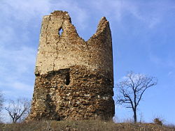
Although small, the village has several distinctive features: a thermal spa, Vrdnik-Ravanica monastery from the 16th century, former coal mine with steam power plant built in 1911, but destroyed during NATO bombing of Yugoslavia in 1999, and a ruined castle, known as Castellum Rednek or Vrdnička kula (Tower of Vrdnik).
Vrdnik is placed near the heart of Fruška Gora, in a valley surrounded by its slopes, at elevation of 181–260 m and coordinates 45°07′N 19°47′E / 45.117°N 19.783°ECoordinates: 45°07′N 19°47′E / 45.117°N 19.783°E. The valley is formed by three creeks named Dubočaš, Morintov potok and Veliki potok. Most houses are built in lines (colonies) along steep streets leading uphill from the town center.
...
Wikipedia
