Volta Redonda
| Volta Redonda | |||
|---|---|---|---|
| Municipality | |||
| Municipality of Volta Redonda | |||

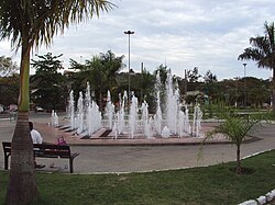
Oscar Cardoso square
|
|||
|
|||
| Nickname(s): Cidade do Aço ("City of Steel") | |||
| Motto: Flumen Fulmini Flexit ("The River Bent Before the Lightning") | |||
 |
|||
| Coordinates: 22°31′22″S 44°06′14″W / 22.52278°S 44.10389°W | |||
| Country |
|
||
| Region | Southeast | ||
| State |
|
||
| Founded | July 17, 1954 | ||
| Government | |||
| • Mayor | Samuca Silva (PV) (2017–2020) | ||
| Area | |||
| • Total | 182.483 km2 (70.457 sq mi) | ||
| Elevation | 390 m (1,280 ft) | ||
| Population (2010 est.)[1] | |||
| • Total | 257,803 | ||
| • Density | 1,400/km2 (3,700/sq mi) | ||
| Time zone | UTC-3 (UTC-3) | ||
| • Summer (DST) | UTC-2 (UTC-2) | ||
Coordinates: 22°31′22″S 44°06′14″W / 22.52278°S 44.10389°W
Volta Redonda (Portuguese pronunciation: [ˈvɔwtɐ ʁeˈdõdɐ]) is the name of a municipality in the Rio de Janeiro state of Brazil with an area of 182.81 km², located from 350m to 707m above the sea level (22º31'23" S, 44º06'15" W) and with a population of 259,811 inhabitants (estimated in 2009). The area around the city has nearly 700,000 km². Its name (which is Portuguese for Round Turn) is due to the round shape of a curve in the Paraíba do Sul river around which the city was built.
Situated in Volta Redonda is Companhia Siderurgica Nacional (CSN), Brazil's second largest steel producer. Today its economy, despite still being based on industry, is quite diverse, and largely focused on the areas of services and trade. Due to this, Volta Redonda is worldly known as Cidade do Aço (which is Portuguese for Steel City).
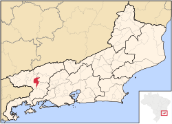
The city borders with the municipalities of Barra Mansa (north, northwest, west and southwest), Barra do Piraí (northeast), Pinheiral, Piraí (south and east), and Rio Claro (south) and is 130 km from the city of Rio de Janeiro.
...
Wikipedia


