Vlieland
| Vlieland | |||
|---|---|---|---|
| Municipality | |||

Lighthouse on Vlieland
|
|||
|
|||
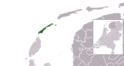
 Location in Friesland |
|||
| Coordinates: 53°18′N 5°4′E / 53.300°N 5.067°ECoordinates: 53°18′N 5°4′E / 53.300°N 5.067°E | |||
| Country | Netherlands | ||
| Province | Friesland | ||
| Government | |||
| • Body | Municipal council | ||
| • Mayor | Ella Schadd-de Boer (PvdA) | ||
| Area | |||
| • Total | 315.80 km2 (121.93 sq mi) | ||
| • Land | 36.13 km2 (13.95 sq mi) | ||
| • Water | 279.67 km2 (107.98 sq mi) | ||
| Elevation | 3 m (10 ft) | ||
| Population (May 2014) | |||
| • Total | 1,113 | ||
| • Density | 31/km2 (80/sq mi) | ||
| Demonym(s) | Vlielander | ||
| Time zone | CET (UTC+1) | ||
| • Summer (DST) | CEST (UTC+2) | ||
| Postcode | 8899 | ||
| Area code | 0562 | ||
| Website | www |
||
Vlieland (Dutch pronunciation: [ˈvlilɑnt]; West Frisian: Flylân) is a municipality and island in the northern Netherlands. The municipality of Vlieland has only one major town: Oost-Vlieland (West Frisian: East-Flylân). It is the second-least densely populated municipality in the Netherlands (after Schiermonnikoog).
Vlieland is one of the West Frisian Islands, lying in the Wadden Sea. It is the second island from the west in the chain, lying between Texel and Terschelling. The island was permanently separated from the mainland in St. Lucia's flood in 1287. Vlieland was named after the Vlie, the seaway between it and Terschelling that was the estuary of the river IJssel in medieval times.
The northern part of the island of Texel, Eierland, once was the southwestern part of Vlieland. A storm surge in 1296 probably separated Eierland from Vlieland. Erosion further diminished the size of Vlieland from the west, leading in 1736 to the disappearance of a second village on Vlieland, West-Vlieland (Westeijnde), after the inhabitants had tried for decades to rebuild the town following numerous floods.
Until 1942 Vlieland, like Terschelling, was part of the province of North Holland. During the Second World War, Vlieland became part of the German Atlantic Wall. The Germans built two anti-aircraft batteries and stationed more soldiers on the island than there were inhabitants. They also repartitioned the island to Friesland and the situation was not reversed after the war. The in the western part of the island is a reminder that in the past mail was delivered by ferry from Texel.
...
Wikipedia


