Vleuten
| Vleuten | |
|---|---|
| Neighbourhood of Utrecht | |

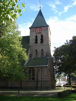
Torenpleinkerk te Vleuten
|
|
 |
|
 The town centre (dark green) and the statistical district (light green) of Vleuten in the municipality of Utrecht. |
|
| Coordinates: 52°6′29″N 5°0′54″E / 52.10806°N 5.01500°ECoordinates: 52°6′29″N 5°0′54″E / 52.10806°N 5.01500°E | |
| Country | Netherlands |
| Province | Utrecht |
| Municipality | Utrecht |
| Population (2013) | |
| • Total | 6,915 |
| Time zone | CET (UTC+1) |
| • Summer (DST) | CEST (UTC+2) |
Vleuten is a former village in the Dutch province of Utrecht. It is a neighbourhood of the city of Utrecht, and lies about 6 km west of it. Vleuten has a railway station on the line between Utrecht and Woerden.
In 2001, Vleuten had 7434 inhabitants. The built-up area was 1.4 km2, and contained 2979 residences. The statistical area "Vleuten" has a population of around 7090.
Vleuten used to be a separate municipality, until it merged with a number of other municipalities in 1954 to form Vleuten-De Meern. In 2001, that municipality merged with the municipality of Utrecht to become a city part of it.
...
Wikipedia
