
Visbek
| Visbek | ||
|---|---|---|
|
||

Visbek
|
||
|
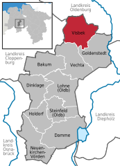
Location of Visbek within Vechta district
  |
||
| Coordinates: 52°50′11.74″N 08°18′35.12″E / 52.8365944°N 8.3097556°ECoordinates: 52°50′11.74″N 08°18′35.12″E / 52.8365944°N 8.3097556°E | ||
| Country | Germany | |
| State | Lower Saxony | |
| District | Vechta | |
| Government | ||
| • Mayor | Gerd Meyer (CDU) | |
| Area | ||
| • Total | 84.08 km2 (32.46 sq mi) | |
| Population (2015-12-31) | ||
| • Total | 9,656 | |
| • Density | 110/km2 (300/sq mi) | |
| Time zone | CET/CEST (UTC+1/+2) | |
| Postal codes | 49429 | |
| Dialling codes | 04445, 04447 (Hagstedt) | |
| Vehicle registration | VEC | |
| Website | www.visbek.de | |

Visbek (Old Saxon Fiscbechi or Fiskbeki) is a municipality in the district of Vechta, in the Oldenburg Münsterland region of the state of Lower Saxony, Germany.
Visbek lies on the North German Plain, approximately 12 km to the north of Vechta. The municipality consists of the village of Visbek itself, together with 13 surrounding hamlets (German: Bauerschaften), viz. Astrup, Bonrechtern, Endel, Erlte, Hagstedt, Halter/ Meyerhöfen, Hogenbögen, Norddöllen, Rechterfeld, Varnhorn/ Siedenbögen and Wöstendöllen.
Neighbouring communities are (counting clockwise from north): the municipality of Großenkneten, including Ahlhorn, the town of Wildeshausen, the municipality of Goldenstedt, the town of Vechta and the municipality of Emstek.
Visbek is the northernmost municipality in Vechta district, bordering the rural districts of Cloppenburg and Oldenburg. To the west, north and east of the village of Visbek, lies the long, narrow strip of the nature reserve of Streams of the Endel and Holzhausen Heath, with the geest brooks and wet lowlands of the Aue, Twillbäke and Visbeker Bruchbach streams with their associated watermills.
...
Wikipedia