Viqueque District
|
Viqueque Vikeke |
||
|---|---|---|
| District | ||

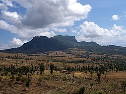
Rice fields in Viqueque
|
||
|
||
 Map of East Timor highlighting Viqueque District |
||
| Coordinates: 8°47′S 126°22′E / 8.783°S 126.367°ECoordinates: 8°47′S 126°22′E / 8.783°S 126.367°E | ||
| Country |
|
|
| Capital | Viqueque | |
| Subdistricts | Lacluta, Ossu, Uato-Lari, Uato Carabau, Viqueque | |
| Area | ||
| • Total | 1,877 km2 (725 sq mi) | |
| Area rank | 1st | |
| Population (2015) | ||
| • Total | 77,402 | |
| • Rank | 5th | |
| • Density | 41/km2 (110/sq mi) | |
| • Density rank | 10th | |
| Households | ||
| • Total | 15,115 (as of 2004) | |
| • Rank | 5th | |
| Time zone | UTC+9 | |
| ISO 3166 code | TL-VI | |
Viqueque (Tetum: Vikeke) is the largest of the districts of East Timor. It has a population of 77,402 (Census 2010) and an area of 1,877 km². The capital of the district is also named Viqueque. The subdistricts are Lacluta,Ossu, Uato-Lari (which was known in Portuguese Timor as Leça, and, in Tetum, is spelled Watulari), Uato Carabau (spelled Watucarbau, in Tetum) and Viqueque. The district was the same in colonial times.
Viqueque is on the south coast of Timor, on the Timor Sea. It borders the districts Baucau to the north, Lautém to the east, and Manatuto to the west.
Viqueque is a homeland of the Malayo-Polynesian language Tetum. In East Timor it is co-official with Portuguese. In the east part of the district live speakers of the Papuan language Makasae.
On the south coast, the people report both myths and possible occurrences of crocodiles.
...
Wikipedia

