Villavicencio
| Villavicencio | |||
|---|---|---|---|

Center of Villavicencio
|
|||
|
|||
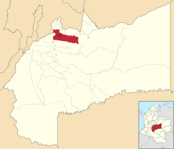
 Location map of the municipality and city of Villavicencio in the Department of Meta. |
|||
| Location in Colombia | |||
| Coordinates: 4°9′N 73°38′W / 4.150°N 73.633°WCoordinates: 4°9′N 73°38′W / 4.150°N 73.633°W | |||
| Country |
|
||
| Region | Orinoquía | ||
| Department | Department of Meta | ||
| Founded | 1840 | ||
| Government | |||
| • Mayor | Wilmar Orlando Barbosa Rozo | ||
| Area | |||
| • City | 1,328 km2 (513 sq mi) | ||
| Elevation | 467 m (1,532 ft) | ||
| Population (2016) | |||
| • City | 495,200 | ||
| • Density | 370/km2 (970/sq mi) | ||
| • Urban | 471,372 | ||
| Demonym(s) | Villavicense | ||
| Time zone | Eastern Time Zone (UTC-05) | ||
| Area code(s) | 57 + 8 | ||
| Website | Official website (Spanish) | ||
Villavicencio (Spanish pronunciation: [biʎaβiˈsensjo]) is a city and municipality in Colombia, capital of Meta department, it was founded on April 6, 1840. The city has approximately 495,200 inhabitants of urban population in 2016.1 The city is located at 4°08'N, 73°40'W, 75 km (about 45 m) southeast of the Colombian capital city of Bogotá (DC) by the Guatiquía River. It is the most important commercial center in the Llanos Orientales (Eastern plains). It has a warm and humid climate, with average temperatures of 28 °C and 30 °C.2 It is affectionately called "Villavo" la bella.
Lying in a rural zone of tropical climate, Villavicencio is on the great Colombian-Venezuelan plain called Los Llanos, which is situated to the east of the Andes mountains. Villavicencio is also called "La Puerta al Llano", or "The Gateway to the Plains", due to its location on the historical path from the Colombian interior to the vast savannas that lie between the Andes range and the Amazon rainforest.
Villavicencio's proximity to huge mountains and great plains make the city an example of Colombia's geodiversity. Because it is located in the foothills of the Andes, the morning and evening breezes cool the city that is very hot for most of the day.
The German Conquistador Nikolaus Federmann reached the altiplano of Bogotá in 1536 by approaching it from the plains of Venezuela, a large unsettled area that is formed by the Orinoco basin. However, this vast area remained unexplored and uncolonized for the next 300 years. Colombia was settled along the mountainous folds of the Magdalena and Cauca valleys, and all of its commerce with the outside world was oriented towards the Caribbean Sea, thus, because of its mountainous barriers, the extreme heat, and inhospitable climate, the Llanos remained forgotten and unsettled.
...
Wikipedia


