Villarrica Volcano
| Villarrica Volcano | |
|---|---|

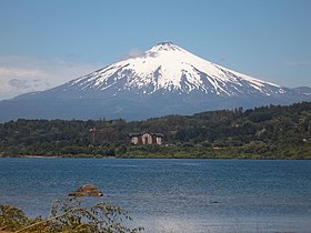
View of Villarrica Lake and the eponymous volcano
|
|
| Highest point | |
| Elevation | 2,860 m (9,380 ft) |
| Prominence | 1,575 m (5,167 ft) |
| Listing |
Region high point Ultra |
| Coordinates | 39°25′15″S 71°56′21″W / 39.42083°S 71.93917°WCoordinates: 39°25′15″S 71°56′21″W / 39.42083°S 71.93917°W |
| Naming | |
| Translation | Place of Wealth (Spanish) |
| Geography | |
| Location | Southern Chile |
| Parent range | Andes |
| Geology | |
| Age of rock | < |
| Mountain type | Stratovolcano |
| Volcanic belt | South Volcanic Zone |
| Last eruption | December 2014 to June 2015 |
| Climbing | |
| First ascent | 1883, Chilean Army |
| Easiest route | Villarrica ski centre - Piedra Negra |
| 2015 eruption of Villarrica | |
|---|---|
| Volcano | Villarrica |
| Date | March 3, 2015 |
| Type | Strombolian |
| Location |
Villarrica, Araucania Region |
| VEI | 2 |
Villarrica (pronunciation: /ˌviːəˈriːkə/ VEE-ə-REE-kə) (Spanish: Volcán Villarrica, Mapudungun: Ruka Pillañ) is one of Chile's most active volcanoes, rising above the lake and town of the same name, 750 km (470 mi) south of Santiago. It is also known as Rucapillán, a Mapuche word meaning "Pillan's house". It is the westernmost of three large stratovolcanoes that trend NW-SW obliquely perpendicular to the Andean chain along the Mocha-Villarrica Fault Zone, along with Quetrupillán and the Chilean portion of Lanín, are protected within Villarrica National Park. Guided ascents are popular during summer months.
Villarrica, with its lava of basaltic-andesitic composition, is one of a small number worldwide known to have an active (but in this case intermittent) lava lake within its crater. The volcano usually generates strombolian eruptions with ejection of incandescent pyroclasts and lava flows. Rainfall plus melted snow and glacier ice can cause massive lahars (mud and debris flows), such as during the eruptions of 1964 and 1971.
...
Wikipedia

