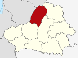
Vileyka Voblast
| Vileyka Voblast Вілейская вобласць Вилейская область |
|||||
| Voblast of the Byelorussian SSR | |||||
|
|||||
|
Map of the Byelorussian SSR in 1940, of which Vileyka Voblast was a part. |
|||||
| Capital |
Vileyka 54°29′N 26°55′E / 54.483°N 26.917°ECoordinates: 54°29′N 26°55′E / 54.483°N 26.917°E |
||||
| History | |||||
| • | Established | December 4, 1939 | |||
| • | Disestablished | September 20, 1944 | |||
| Area | |||||
| • | 1941 | 20,700 km2(7,992 sq mi) | |||
| Population | |||||
| • | 1941 | 938,000 | |||
| Density | 45.3 /km2 (117.4 /sq mi) | ||||
| Political subdivisions | 22 raions | ||||
Vileyka Voblast (Belarusian: Вілейская вобласць, Russian: Вилейская область) was a territorial unit in the Belarusian Soviet Socialist Republic created out of the eastern powiats of the Wilno Voivodeship after the annexation of West Belarus (then part of Poland) into the BSSR in November 1939. The administrative centre of the province was the city of Vileyka.
Initially the oblast consisted of Vileyka, Ashmyany, Braslav, Dzisna, Postavy and Sventiany raions. In January 1940, it consisted of 22 raions: Ostrovets, Oshmyany, Braslav, Vidzy, Gadutsishki, Glubokoye, Dzisna, Dokshitsi, Dunilovichi, Ilya, Krivichi, Kurenets, Molodechno, Miory, Miadzieł, Postavy, Wagtails (its centre was Plisa), Radashkovichy, Smorgon, Sventiany, Svir and Dergachi (its centre was Sharkovshchina). On November 1940, the raions of Gadutsishki and Sventiany as well as parts of the Ostrovets, Oshmyany, Postavy and Svir raions were transferred to the Lithuanian SSR. Also, during the German occupation between 1941 and 1944, Oshmyany raion was part of Wilna Land General Bezirk at Litauen and the city of Vileyka Glubokoye was part of General Bezirk Weissruthenien in Reichskommissariat Ostland.
...
Wikipedia

