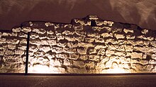
Vestiges of the Gallo-Roman wall, Grenoble
| Vestiges de l’enceinte Gallo-Romaine (French) | |
|
The Vestiges of the Gallo-Roman Walls (Grenoble)
|
|
| Location |
Grenoble, |
|---|---|
| Region | Rhône-Alpes |
| Coordinates | 45°11′35″N 5°43′55″E / 45.19292°N 5.73208°ECoordinates: 45°11′35″N 5°43′55″E / 45.19292°N 5.73208°E |
| Type | Defensive wall and Status symbol |
| Part of | Grenoble |
| Length | 1.5 km (0.93 mi) |
| Width | Up to 4 m (13 ft) |
| Area | 9 Hectares (90000 sq. meters) |
| History | |
| Builder | Roman Army |
| Material |
Limestone Pebble Mortar |
| Founded | 286-293 AD |
| Site notes | |
| Condition | Remaining sections: Either semi-ruinous or partly restored |
| Public access | Open to Public |
| Designation | Cultural |
The Vestiges (traces) of the Gallo-Roman wall are the remains of a fortification, constructed in Grenoble, France (formerly called Cularo) at the end of the 3rd century, under the reign of the Emperors Diocletian and Maximian. The status of Civitas marked the city of Cularo as an administrative capital of the Roman Empire. The Gallo-Roman wall was 1,150 meters in length, and had 39 semi-circular watchtowers which were 7.5 meters in diameter. It had two monumental gates decorated by inscriptions identifying the two Roman emperors. The Gallo-Roman wall played an important role in the protection of the 9-hectare urban surface of the Roman settlement. It served as a symbol of the status of Civitas. The wall was built up of small limestone blocks and was covered with plaster. Some parts of the wall were 4 meters thick and made up of limestone, pebble and tuileau rubble. These materials were held together by mortar.
This defensive construction was between four and five meters thick. The two doors of the surrounding wall were built on stone blocks reused from previous buildings such as funerary monuments. Close to the foundation of the Viennoise door, inscriptions can be found on the stones, which attributes them to earlier funerary monuments. Vertically planted wooden stakes served as foundation for the construction. Every side of the wall was formed by a regular setting of rubble-stone. Inside, the blockage was composed of diverse materials, and covered in whitewash mortar. The initial height of the wall was approximately nine meters. The total length of the wall was close to 1200 meters, set up in the shape of an oval. This defensive structure had a ditch that was full of water, which linked it to the Isère (river) to form a protective moat.
Prior to the construction of the wall in the end of the 3rd century AD, the Gallic city of Cularo (Grenoble) was surrounded by a fence and a ditch. During the Roman Peace (Pax Romana) period (27 BC to 180 AD), the walls were not guarded. In the 3rd century, the city was weakened by the invasion of barbarians, so the Gallo-romans built a surrounding wall, under the rule of the Emperor Diocletian. The wall surrounding Cularo covered 9 hectares of land and had two main gates. At the time, the city had an approximate population of 2000 inhabitants. Cularo appears on the Tabula Peutingeriana, but in the Latin version of Cularone
...
Wikipedia


