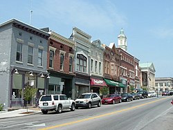
Versailles, Kentucky
| Versailles, Kentucky | |
|---|---|
| City | |

Main Street
|
|
| Motto: "Proud to be a Kentucky Renaissance City" | |
 Location of Versailles, Kentucky |
|
| Coordinates: 38°3′17″N 84°43′51″W / 38.05472°N 84.73083°WCoordinates: 38°3′17″N 84°43′51″W / 38.05472°N 84.73083°W | |
| Country | United States |
| State | Kentucky |
| County | Woodford |
| Established | June 23, 1792 |
| Government | |
| • Type | Mayor-Council |
| • Mayor | Brian Traugott |
| Area | |
| • Total | 2.8 sq mi (7 km2) |
| • Land | 2.8 sq mi (7 km2) |
| • Water | 0.0 sq mi (0 km2) |
| Elevation | 892 ft (272 m) |
| Population (2010) | |
| • Total | 8,568 |
| • Density | 2,976.7/sq mi (1,149.3/km2) |
| Time zone | Eastern (EST) (UTC-5) |
| • Summer (DST) | EDT (UTC-4) |
| ZIP codes | 40383, 40384, 40386 |
| Area code(s) | 859 |
| FIPS code | 21-79482 |
| GNIS feature ID | 0506028 |
| Website | http://www.versaillesky.com |
Versailles (/vərˈseɪlz/) is a city in Woodford County, Kentucky, United States and is located near Lexington. It is part of the Lexington-Fayette Metropolitan Statistical Area. The population was 8,568 at the 2010 census. It is the county seat of Woodford County. The city's name is pronounced ![]() i/vərˈseɪlz/ vər-SAYLZ, not like the French city of the same name.
i/vərˈseɪlz/ vər-SAYLZ, not like the French city of the same name.
Versailles was founded on June 23, 1792, on 80 acres (320,000 m2) of land owned by Hezekiah Briscoe, at the time only a child. His guardian, Major Marquis Calmes, named the town after Versailles, France, in honor of General Lafayette, a family friend. In the Bluegrass Region of Kentucky, which became known for its thoroughbred horses and other livestock, the city was officially incorporated on February 13, 1837. It was briefly occupied during the American Civil War by both Confederate and Union forces.
...
Wikipedia
