Verosvres
| Verosvres | |
|---|---|
| Commune | |

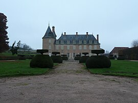
Chateau of Terreau
|
|
| Coordinates: 46°24′05″N 4°26′38″E / 46.4014°N 4.4439°ECoordinates: 46°24′05″N 4°26′38″E / 46.4014°N 4.4439°E | |
| Country | France |
| Region | Bourgogne-Franche-Comté |
| Department | Saône-et-Loire |
| Arrondissement | Charolles |
| Canton | Saint-Bonnet-de-Joux |
| Area1 | 22.96 km2 (8.86 sq mi) |
| Population (2006)2 | 596 |
| • Density | 26/km2 (67/sq mi) |
| Time zone | CET (UTC+1) |
| • Summer (DST) | CEST (UTC+2) |
| INSEE/Postal code | 71571 /71220 |
| Elevation | 326–596 m (1,070–1,955 ft) (avg. 386 m or 1,266 ft) |
|
1 French Land Register data, which excludes lakes, ponds, glaciers > 1 km² (0.386 sq mi or 247 acres) and river estuaries. 2Population without double counting: residents of multiple communes (e.g., students and military personnel) only counted once. |
|
1 French Land Register data, which excludes lakes, ponds, glaciers > 1 km² (0.386 sq mi or 247 acres) and river estuaries.
Verosvres is a commune in the Saône-et-Loire department in the region of Bourgogne in eastern France.
The name Verosvres is derived from the Gallic word Verobriga, vero meaning "true" or "good" and briga meaning "fortress": thus giving "Good castle".
In 1920, the town of Verosvres formed "an agglomeration of about eighty houses, including one for the post office and telegraph." The town was then served by a railway line, now defunct, which connected Paray-le-Monial to Mâcon, and stopped at a station called "Les Terreaux — Verosvres".
...
Wikipedia


