Vermont Route 119
| New Hampshire Route 119 | |||||||
|---|---|---|---|---|---|---|---|

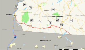
Map of southwestern New Hampshire and southeastern Vermont with NH 119 and VT 119 highlighted in red
|
|||||||
| Route information | |||||||
| Maintained by NHDOT | |||||||
| Length: | 39.988 mi (64.354 km)
|
||||||
| Major junctions | |||||||
| West end: |
|
||||||
|
|
|||||||
| East end: |
|
||||||
| Location | |||||||
| Counties: | VT: Windham, NH: Cheshire, Hillsborough | ||||||
| Highway system | |||||||
|
|||||||
New Hampshire Route 119 (NH 119) is a state highway in the U.S. state of New Hampshire. The highway begins in Hinsdale at the Connecticut River, across which the highway continues into Brattleboro, Vermont, as Vermont Route 119 (VT 119) for 0.080 miles (0.129 km) to its terminus at U.S. Route 5 (US 5) and VT 142. NH 119 heads east 39.908 miles (64.226 km) to the Massachusetts state line in New Ipswich, where the highway continues as Massachusetts Route 119. The state highway is the main east–west highway of southern Cheshire County, where it connects the towns of Hinsdale, Winchester, Richmond, Fitzwilliam, and Rindge.
...
Wikipedia


