Velankanni Town
|
Velankanni வேளாங்கண்ணி |
|
|---|---|
| town | |
 |
|
| Location in Tamil Nadu, India | |
| Coordinates: 10°42′N 79°48′E / 10.70°N 79.80°ECoordinates: 10°42′N 79°48′E / 10.70°N 79.80°E | |
| Country |
|
| State | Tamil Nadu |
| District | Nagapattinam |
| Area | |
| • Total | 5.5 km2 (2.1 sq mi) |
| Elevation | 87.78 m (287.99 ft) |
| Population (2001) | |
| • Total | 10,144 |
| • Density | 1,800/km2 (4,800/sq mi) |
| Languages | |
| • Official | Tamil |
| PIN | 611111 |
| Telephone code | 914365 |
| Vehicle registration | TN 51 |
| Website | www |
Velankanni (Tamil: வேளாங்கண்ணி Vēḷāṅkaṇṇi), is a panchayat town in Nagapattinam district in the Indian state of Tamil Nadu. It lies on the Coromandel Coast of the Bay of Bengal, 350 km south of Chennai (Madras) and 12 km south of Nagapattinam.
Once a port that traded with Rome and Greece, the tiny commercial center gradually lost its importance to the larger city of Nagapattinam. The canal built to link this town with Vedaranyam still lies to the west. The Vellayar, a minor branch of the Cauvery River, runs south of the town and discharges into the sea. The town was among the worst hit by the tsunami caused by the 2004 Indian Ocean earthquake.
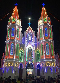
The town is home to a significant Roman Catholic Latin Rite shrine called the Basilica of Our Lady of Good Health.
Velankanni has been chosen as one of the heritage cities for HRIDAY - Heritage City Development and Augmentation Yojana scheme of Government of India.
...
Wikipedia

