Vauvert
| Vauvert | ||
|---|---|---|

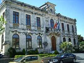
Vauvert town hall
|
||
|
||
| Coordinates: 43°41′39″N 4°16′37″E / 43.6942°N 4.2769°ECoordinates: 43°41′39″N 4°16′37″E / 43.6942°N 4.2769°E | ||
| Country | France | |
| Region | Occitanie | |
| Department | Gard | |
| Arrondissement | Nîmes | |
| Canton | Vauvert | |
| Intercommunality | Petite-Camargue | |
| Government | ||
| • Mayor (2015-2020) | Jean Denat | |
| Area1 | 109.86 km2 (42.42 sq mi) | |
| Population (2012)2 | 11,261 | |
| • Density | 100/km2 (270/sq mi) | |
| Time zone | CET (UTC+1) | |
| • Summer (DST) | CEST (UTC+2) | |
| INSEE/Postal code | 30341 /30600 | |
| Elevation | 0–97 m (0–318 ft) (avg. 18 m or 59 ft) |
|
|
1 French Land Register data, which excludes lakes, ponds, glaciers > 1 km² (0.386 sq mi or 247 acres) and river estuaries. 2Population without double counting: residents of multiple communes (e.g., students and military personnel) only counted once. |
||
1 French Land Register data, which excludes lakes, ponds, glaciers > 1 km² (0.386 sq mi or 247 acres) and river estuaries.
Vauvert is a commune in the far south of the Gard department in southern France. It was known as Posquières in the Middle Ages. The commune comprises the town of Vauvert and the villages of Gallician and Montcalm. Over a third of the population work in industry, which is largely the food industry, especially wine production. The original settlement was called Posquières and was first mentioned in a document of 810. Since then the town has increased in importance and has had a rich history. At its heyday in the mid-nineteenth century it had a population of 6,000 but this decreased by a third after disease struck the grape crop, the mainstay of the economy of the area. Today, the population has grown again to over 11,000.
Vauvert is first mentioned as the fief of Posquières (meaning "place of wells") when it was donated by Raymond Raphiel to Saint-Thibéry Abbey in 810. In the Middle Ages, a little village grew up around the frequently besieged castle on top of the Motte-Foussat, now known as Castellas. The Christians and the Jews created two separate communities in the village. In the 12th century, the rabbinical school was an important centre of Jewish teaching, recognized across Europe thanks to the contributions of Abraham ben David and Isaac the Blind. From the 13th century, the Christian sanctuary Notre-Dame du Val-Vert, just outside the village, gained increasing importance when it was visited by Louis IX, Charles IX, Francis I and Pope Clement V. As a result, in the 14th century the name of the village was changed to Vauvert. In 1540, the sanctuary was destroyed by the Protestants. The town was considered strategically important by Montmorency in his campaign of 1627 during the reign of Louis XII. After the revocation of the Edict of Nantes, the Protestant church, Temple Vielh, was destroyed in 1685 and the Catholic church was rebuilt and consecrated in 1689.
...
Wikipedia


