Variko
|
Variko Βαρικό |
|
|---|---|
| Coordinates: 40°32.30′N 21°30′E / 40.53833°N 21.500°ECoordinates: 40°32.30′N 21°30′E / 40.53833°N 21.500°E | |
| Country | Greece |
| Administrative region | West Macedonia |
| Regional unit | Florina |
| Municipality | Amyntaio |
| • Municipal unit | 21.9 km2 (8.5 sq mi) |
| Elevation | 770 m (2,530 ft) |
| Population (2011) | |
| • Municipal unit | 638 |
| • Municipal unit density | 29/km2 (75/sq mi) |
| Time zone | EET (UTC+2) |
| • Summer (DST) | EEST (UTC+3) |
| Postal code | 500 05 |
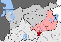
Variko (Greek: Βαρικό, Bulgarian: Мокрени, Macedonian: Мокрени) is a village and a former community in Florina regional unit, West Macedonia, Greece. Since the 2011 local government reform it is part of the municipality Amyntaio, of which it is a municipal unit. The municipal unit has an area of 21.877 km2. It is 27 km south-southeast of the city of Florina. The population in 2011 was 638. The village's primary agricultural products are beans, corn, and wheat. There is an annual bean festival on August 15, coinciding with the Dormition of Virgin.
The village was first mentioned in an Ottoman defter of 1481, under the name of Mokreni, and was described as having sixty-nine households. In the beginning of 19th century Francois Pouqueville noted Mocrena as one of the Bulgarian villages in the region. The population of Mocreni was Bulgarian in 19th and early 20th centuries. The population of the village was under the supremacy of the Bulgarian Exarchate since 1891.
The village was burned by the Turks during the Ilinden Uprising. There was a Bulgarian school in the village in the beginning of the 20th century. After the Treaty of Bucharest in 1913, when the area became part of Greece, many people emigrated to Bulgaria. The village was renamed Variko in 1926.
...
Wikipedia


