Vanclans
| Vanclans | |
|---|---|

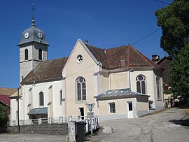
Church Notre-Dame des Anges
|
|
| Coordinates: 47°06′04″N 6°21′43″E / 47.1011°N 6.3619°ECoordinates: 47°06′04″N 6°21′43″E / 47.1011°N 6.3619°E | |
| Country | France |
| Region | Bourgogne-Franche-Comté |
| Department | Doubs |
| Arrondissement | Pontarlier |
| Canton | Valdahon |
| Area1 | 9.6 km2 (3.7 sq mi) |
| Population (2012)2 | 208 |
| • Density | 22/km2 (56/sq mi) |
| Time zone | CET (UTC+1) |
| • Summer (DST) | CEST (UTC+2) |
| INSEE/Postal code | 25585 /25580 |
| Elevation | 690–978 m (2,264–3,209 ft) |
|
1 French Land Register data, which excludes lakes, ponds, glaciers > 1 km² (0.386 sq mi or 247 acres) and river estuaries. 2Population without double counting: residents of multiple communes (e.g., students and military personnel) only counted once. |
|
1 French Land Register data, which excludes lakes, ponds, glaciers > 1 km² (0.386 sq mi or 247 acres) and river estuaries.
Vanclans is a former commune in the Doubs department in the Bourgogne-Franche-Comté region in eastern France.
Vanclans lies 8 km (5.0 mi) west of Vercel and 10 km (6.2 mi) southeast of Valdahon. It is nestled between two hills at the foot of the first slopes of evergreens.
On 1 January 2016, Athose, Chasnans, Hautepierre-le-Châtelet, Nods, Rantechaux and Vanclans merged becoming one commune called Les Premiers-Sapins.
...
Wikipedia


