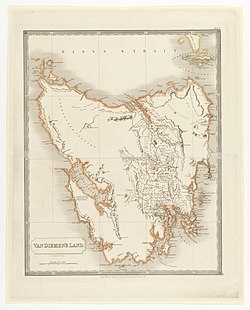
Van Diemens Land
| Van Diemen's Land | |||||
| British Crown Colony | |||||
|
|||||
| 1828 map | |||||
| Government | Self-governing colony | ||||
| Monarch | |||||
| • | 1825–1837 | William IV | |||
| • | 1837–1856 | Victoria | |||
| Lieutenant-Governor | |||||
| • | 1825–1836 | Sir George Arthur first | |||
| • | 1855–1856 | Henry Young last | |||
| History | |||||
| • | independence from the Colony of New South Wales | 3 December 1825 | |||
| • | Name changed to Tasmania | 1856 | |||

1852 map of Van Diemen's Land.
|
|
| Geography | |
|---|---|
| Location | Southern Ocean |
| Coordinates | 42°00′S 147°00′E / 42.000°S 147.000°E |
| Area | 68,401 km2 (26,410 sq mi) |
| Highest elevation | 1,614 m (5,295 ft) |
| Highest point | Mount Ossa |
| Administration | |
|
Australia
|
|
| Largest settlement | Hobart Town |
| Demographics | |
| Population | 40,000 (1855) |
| Pop. density | 0.59 /km2 (1.53 /sq mi) |
| Ethnic groups | European Australians, Aboriginal Tasmanians |
Van Diemen's Land was the original name used by most Europeans for the island of Tasmania, now part of Australia. The name was changed from Van Diemen's Land to Tasmania in 1856.
The Dutch explorer Abel Tasman was the first European to land on the shores of Tasmania in 1642. Landing at Blackman's Bay and later having the Dutch flag flown at North Bay, Tasman named the island Anthoonij van Diemenslandt, in honour of Anthony van Diemen, the Governor-General of the Dutch East Indies, who had sent Tasman on his voyage of discovery. Between 1772 and 1798, only the southeastern portion of the island was visited. Tasmania was not known to be an island until Matthew Flinders and George Bass circumnavigated it in the Norfolk in 1798–99.
Around 1784-85, Henri Peyroux de la Coudrenière, an army officer serving in Spanish Louisiana, wrote a "memoir on the advantages to be gained for the Spanish crown by the settlement of Van Dieman's Land". After receiving no response from the Spanish government, Peyroux proposed it to the French government, as "Mémoire sur les avantages qui résulteraient d'une colonie puissante à la terre de Diémen".
...
Wikipedia


