Van Buren County, Missouri
| Cass County, Missouri | |
|---|---|
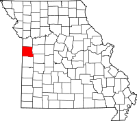
 Location in the U.S. state of Missouri |
|
 Missouri's location in the U.S. |
|
| Founded | March 3, 1835 |
| Named for | Lewis Cass |
| Seat | Harrisonville |
| Largest city | Belton |
| Area | |
| • Total | 702 sq mi (1,818 km2) |
| • Land | 697 sq mi (1,805 km2) |
| • Water | 5.7 sq mi (15 km2), 0.8% |
| Population (est.) | |
| • (2015) | 101,603 |
| • Density | 143/sq mi (55/km²) |
| Congressional district | 4th |
| Time zone | Central: UTC-6/-5 |
| Website | www |
| Cass County, Missouri | ||||
|---|---|---|---|---|
| Elected countywide officials | ||||
| Assessor | Bob Huston | Republican | ||
| Circuit Clerk | Kim York | Republican | ||
| County Clerk | Michael Vinck | Republican | ||
| Collector | Pam Shipley | Democratic | ||
|
Commissioner (Presiding) |
Jeff Cox | Republican | ||
|
Commissioner (District 1) |
Monty Kisner | Republican | ||
|
Commissioner (District 2) |
Jimmy Odom | Republican | ||
| Prosecuting Attorney | Ben Butler | Republican | ||
| Public Administrator | Melody Folsom | Republican | ||
| Recorder | Mike Medsker | Republican | ||
| Sheriff | Jeff Weber | Republican | ||
| Treasurer | Steve Cheslik | Republican | ||
| Cass County, Missouri | ||
|---|---|---|
| 2008 Republican primary in Missouri | ||
| John McCain | 3,195 (31.28%) | |
| Mike Huckabee | 3,033 (29.70%) | |
| Mitt Romney | 3,324 (32.55%) | |
| Ron Paul | 477 (4.67%) | |
| Cass County, Missouri | ||
|---|---|---|
| 2008 Democratic primary in Missouri | ||
| Hillary Clinton | 6,500 (59.76%) | |
| Barack Obama | 3,995 (36.73%) | |
| John Edwards (withdrawn) | 302 (2.78%) | |
Cass County is a county located in the western part of the U.S. state of Missouri. As of the 2010 census, the population was 99,478. Its county seat is Harrisonville. The county was organized in 1835 as Van Buren County but was renamed in 1849 after U.S. Senator Lewis Cass of Michigan who later became a presidential candidate.
Cass County is part of the Kansas City, Missouri Metropolitan Statistical Area.
The Harrisonville area was originally inhabited by the Dhegihan Native American subgroup. The Osage, Quapaw, Omaha, Ponca and Kansa tribes make up this Siouan linguistic group. The Kansas tribal range extended southward from the Kansas-Missouri River junction as far as the northern edge of Bates County, Missouri, taking in the sites of modern Pleasant Hill, Garden City, Archie and Drexel. On their southeastern border they were neighbors of the Osage, although there is no evidence that either of these tribes ever had a truly permanent settlement in the territory of Cass County.
Early camp meetings southwest of Harrisonville often had as many as 500 Indians in attendance, as they seemed to enjoy the religious services as much as the white settlers. These visitors were reported to be Shawnee and Delaware, both speaking related Algonquian languages.
...
Wikipedia
