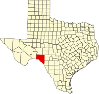
Val Verde County
| Val Verde County, Texas | |
|---|---|

The Val Verde County Courthouse is located at 400 Pecan St. in Del Rio
|
|
 Location in the U.S. state of Texas |
|
 Texas's location in the U.S. |
|
| Founded | 1885 |
| Seat | Del Rio |
| Largest city | Del Rio |
| Area | |
| • Total | 3,233 sq mi (8,373 km2) |
| • Land | 3,145 sq mi (8,146 km2) |
| • Water | 88 sq mi (228 km2), 2.7% |
| Population | |
| • (2010) | 48,879 |
| • Density | 16/sq mi (6/km²) |
| Congressional district | 23rd |
| Time zone | Central: UTC-6/-5 |
| Website | www |
Val Verde County is a county located on the southern Edwards Plateau in the U.S. state of Texas. The 2014 population is 51,047. Its county seat is Del Rio. In 1936, Val Verde County received Recorded Texas Historic Landmark number 5625 to commemorate its founding.
Val Verde, which means "green valley", was named for a battle of the American Civil War. In 1862, soldiers of Sibley's Brigade took part in the Texas invasion of New Mexico Territory, where they captured several artillery pieces at the Battle of Val Verde. The battle is memorialized both in the name of the county and a small settlement in Milam County.
The Del Rio, TX Micropolitan Statistical Area includes all of Val Verde County.
According to the U.S. Census Bureau, the county has a total area of 3,233 square miles (8,370 km2), of which 3,145 square miles (8,150 km2) is land and 88 square miles (230 km2) (2.7%) is water.
As of the census of 2000, there were 44,856 people, 14,151 households, and 11,320 families residing in the county. The population density was 14 people per square mile (5/km²). There were 16,288 housing units at an average density of 5 per square mile (2/km²). The racial makeup of the county was 76.36% White, 4.54% Black or African American, 0.68% Native American, 0.55% Asian, 0.05% Pacific Islander, 18.22% from other races, and 2.60% from two or more races. 75.46% of the population were Hispanic or Latino of any race.
...
Wikipedia
