Val Trebbia
| Trebbia | |
|---|---|

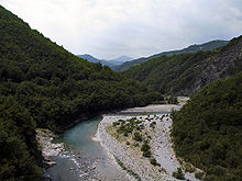
The Trebbia valley in July, a few kilometres upstream from Bobbio
|
|

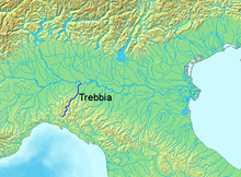
Location of the Trebbia in Italy
|
|
| Country | Italy |
| Basin features | |
| Main source |
Monte Prelà, Ligurian Apennines 800 m (2,600 ft) |
| River mouth |
Po river, right bank, just upstream from Piacenza 61 m (200 ft) |
| Basin size | 1,150 km2 (440 sq mi) |
| Physical characteristics | |
| Length | 118 km (73 mi) |
| Discharge |
|
The Trebbia (stressed Trèbbia; Latin: Trebia) is a river predominantly of Liguria and Emilia Romagna in northern Italy. It is one of the four main right-bank tributaries of the river Po, the other three being the Tanaro, the Secchia and the Panaro. The 1,150-square-kilometre (440 sq mi) drainage basin is divided among Emilia Romagna, 770 square kilometres (300 sq mi), Liguria, 349 square kilometres (135 sq mi), and Lombardy, 31 square kilometres (12 sq mi). Its principal tributaries are the torrents Aveto and Perino (from the right) and the torrent Boreca (from the left).
The source of the river, the Trebbia river spring, is in the Ligurian Apennines on the south slopes of Monte Prelà, to the south of Monte Antola in the comune of Torriglia, Province of Genoa. Monte Prelà, 1,407 m (4,616 ft) high, is part of the Antola massif.
The spring is not on the peak but is at roughly 800 m (2,600 ft). Across a small ridge to the west, on which sits Torriglia, and slightly further downslope is the source of the Scrivia river. Over a ridge to the northeast is the Brugneto reservoir, water supply for Genoa. The reservoir was created in 1959 by damming Brugneto stream, which formerly joined its waters to the Trebbia, but now only does so when the reservoir is full. A ridge running north from Prelà connects to Monte Druso, then to Monte Cremado, and finally to Monte Antola at 1,597 m (5,240 ft). From its peak on a clear day can be seen Genoa, Corsica, the Tuscan Archipelago and the Alps.
...
Wikipedia
