Vaca Range
| Vaca Mountains | |
|---|---|

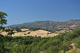
Mt. Vaca and the Blue Ridge, high points of Solano County, as seen from upper Suisun Valley.
|
|
| Highest point | |
| Peak | Mount Vaca |
| Elevation | 859 m (2,818 ft) |
| Geography | |
|
location of the Vaca Mountains in California
|
|
| Country | United States |
| State | California |
| Region | Napa County, Solano County |
| Range coordinates | 38°24′01″N 122°06′22″W / 38.4001881°N 122.1060815°WCoordinates: 38°24′01″N 122°06′22″W / 38.4001881°N 122.1060815°W |
| Topo map | USGS Mount Vaca |
The Vaca Mountains are a mountain range in Napa and Solano Counties, California that is one of the California Coast Ranges. They represent the easternmost of the Inner Coast Ranges in north−central California, and divide the Suisun Valley on their west, from the Sacramento Valley on their east.
The Vaca Mountains are one of the most prominent landmarks of Solano County, with a steep ridge on the east side that rises abruptly 1,000 feet (305 m) or more above the foothills below. The range begins at Suisun Marsh in a broad, low-elevation saddle that also contains the city of Fairfield and Travis Air Force Base, and separates the mountains to the northwest from an outlier of low hills called the Montezuma Hills. The Vaca Mountains then trend 17.5 miles (28 km) to the north and end at Putah Creek Canyon. The average width of the range is about 5.5 miles (9 km), with an area of 61,775 acres (250 km2) that is mostly undeveloped. Mt. Vaca at an elevation 2,818 feet (859 m) is the highest summit, and the high point of Solano County, but the backbone of the range is the Blue Ridge, a prominent ridgetop that maintains an elevation of over 1,900 feet (579 m) for several miles.
Where the Blue Ridge seemingly ends abruptly at Putah Creek Canyon, the mountains continue on the north side of the canyon as the Blue Ridge Range, which is topographically and geologically similar to the Vaca Mountains. Because the canyon is difficult to distinguish from most vantage points on the east side, the Vaca and Blue Ridge Mountains present what appears to be a nearly continuous ridge line that defines the west margin of the Sacramento Valley, which is the northern half of the 400 miles (640 km)-long Central Valley of California.
...
Wikipedia

